


About the Car Show CS FD1030-P11 Navigation Receiver

Add navigation and a big screen to your F-150's SYNC system
Add navigation and a big screen to your F-150's SYNC system
If you've got the SYNC system in your F-150, you don't need to be sold on the benefits it provides. But what if you could add navigation and a great-looking touchscreen to your truck, all while keeping the benefits of SYNC? Car Show's CS FD1030-P11 navigation system gives you the tool to do the job, wrapped up in custom-fit packaging that looks like it was installed at the factory. Even better, this unique system attaches to the SYNC system in your Ford, so you don't have to buy expensive adapters to keep all the useful features that you've grown to love.
GPS navigation — built in
You can navigate to specific addresses or any of the 11 million points of interest — the high-resolution 6.95" touchscreen display shows maps of all 50 states in easy-to-read detail, including 3-D building views in many cities. A built-in database of 2500 red-light and speed cameras provides valuable driving info. When you approach a complicated intersection, your map is replaced by a 3D view of the intersection, while the Lane Information feature clearly points the way to your next turn.
All your original equipment goodies
With this system added onto your original audio system, you'll keep all the features you paid for, including the SYNC controlled CD changer, Bluetooth®, iPod® input, and your steering wheel audio controls. All your SYNC functions will display on the big touchscreen — a nice step up from the factory 2-line display. The system even adds a rear audio/video input for other sources, and includes a rear-view camera that'll provide a color picture of what's behind you when you back up.
Note: The CS FD1030-P11 only works in 2009-up Ford F-150 trucks that were factory-equipped with the SYNC® system. It is not compatible with non-SYNC® and Sony audio system equipped vehicles.
Note: When you install this kit, you will lose access to the vehicle's factory cigarette lighter/power socket.Product highlights:
General features:
- add-on navigation system with touchscreen control for 2009-up SYNC equipped F-150 trucks
- retains factory radio and audio controls, including steering wheel audio controls
- 6.95" touchscreen display
- built-in navigation system with 11 million points of interest
- retains all factory SYNC capabilities
- rear-view camera included
- inputs: adds rear AV input and rear-view camera input
Other information:
- warranty: 1 year
- MFR # CS FD1030-P11
What's in the box:
Car Show CS FD1030-P11 Navigation Receiver owner's manual
- Navigation control screen
- Pre-installed 4GB microSD card (with map data)
- Dash kit
- Vehicle harness
- AV harness
- Rear-view camera (with attached 18" cable terminated by a 3.5mm connector)
- 24.75' Camera harness (terminated by a female 3.5mm jack on one end and a 4-pin proprietary connector on other end)
- GPS antenna (with attached 16' cable terminated by an SMB connector
- Self-adhesive magentic base
- Plastic insert
- 6 Button inserts
- 3 Rubber covers
- Two-sided tape
- Self-adhesive felt-pad
- Velcro
- 6 Speed-clips
- 2 Screws
- Hex-nut
- Star-washer
- Navigation User Manual
- Quick Start Guide
- Installation Guide
- Tech Tip
- Vehicle Waterproof Camera spec sheet
Customer reviews for Car Show CS FD1030-P11 Navigation Receiver
Loading...
Loading reviews...
Average review:
4.0 out of 5 starsThanks for submitting your review
Customer photos


This review was collected as part of a promotion
Pros:
Cons:

More details on the Car Show CS FD1030-P11 Navigation Receiver

Features & specs
| Expandability | ||
|---|---|---|
| AUX Input | No | |
| Audio/video Input | Composite (rear) | |
| USB Input | No | |
| USB Port Power | --- | |
| Backup Camera Input | Yes | |
| Second Camera Input | No | |
| CarPlay | No | |
| Android Auto | No | |
| Siri Control | No | |
| Alexa Voice Control | ||
| Android Control | No | |
| Memory Card Slot | N/A | |
| Bluetooth Compatible | No | |
| Satellite Radio Ready | No | |
| HD Radio | No | |
| Navigation | Yes | |
| iPod Compatibility | ||
| Full size | N/A | |
| Nano | N/A | |
| Touch | N/A | |
| iPhone | N/A | |
| General | ||
| RMS Power (CTA-2006) | N/A | |
| RMS Power (Manufacturer) | --- | |
| Peak Output | N/A | |
| RMS Power Bandwidth | N/A | |
| Preamp Outputs | None | |
| Sub Preamp Outputs | No | |
| Switchable Rear Preamp Outputs | No | |
| Video Screen | Yes | |
| Navigation App Compatible (iOS) | ||
| Navigation App Compatible (Android) | ||
| Preamp Voltage | N/A | |
| Screen Size | 6.95 | |
| Screen Type | Basic (Resistive) | |
| Display Color | ||
| Key Button Color | Wjote | |
| EQ Bands | None | |
| Wireless Remote | No | |
| Steering Wheel Control Compatible | No | |
| Parts Warranty | 1 Year | |
| Labor Warranty | 1 Year | |
| Tuner | ||
| FM Sensitivity | --- | |
| European Tuning | No | |
| Seek/Scan | No | |
| Radio Data System | --- | |
| File Playback | ||
| Music File Playback | N/A | |
| High-res Playback | ||
Product Research
System Features
Built-in Navigation
System Features
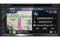
Compatibility: The CarShow CS-FD1030-P11 In-Dash Navigation System is designed specifically for the 2009-2012 Ford F-150 with factory SYNC. The CarShow CS-FD1030-P11 includes a Navigation touchscreen display, Dash kit, vehicle harness, GPS antenna, AV input harness, rear-view camera, and other installation hardware. This unit is simply a navigation control screen add-on for the Ford SYNC system, without a built-in amplifier, AM/FM receiver, or audio controls. The Ford SYNC system stays intact so you still access all its functions through the the Ford F-150 factory SYNC controls.
SYNC Control: The CarShow CS-FD1030-P11 retains all factory SYNC capabilities and other factory installed functions; including:
- SYNC controlled 1 & 6 disc audio system (AM-FM-CD-iPod)
- SYNC controlled Bluetooth hands-free system
- USB port (iPod only) and Aux input (audio only) for multimedia playback
- Steering wheel controls
Touchscreen Display: The CarShow CS-FD1030-P11 In-Dash Navigation System features a 6.95" high-definition touchscreen, anti-glare display with auto and manual dimming control. The 6.95" touchscreen monitor display SYNC, Radio, and other functions in a much higher resolution than the 2-line factory display found in your Ford F150.
Dash Kit: The CarShow CS-FD1030-P11 uses an automotive-grade ABS plastic dash kit (black) that has been designed to match the system's navigation touchscreen panel as well as your Ford F-150's factory control knobs and push-buttons. Unfortunately, the vehicle's factory cigarette lighter/power socket will be lost when using this kit.
AV Input: The CarShow In-Dash Navigation System features a rear-mounted composite video/stereo RCA audio output that allows you to connect an external display and headphone system in the rear of your vehicle. The rear entertainment output mirrors the system's main audio/video source.
Rear View Camera: The CarShow CS-FD1030-P11 In-Dash Navigation System includes a color rear-view camera with reverse trigger, so you can back up safely. The rear-view camera installs within the Ford F-150's tailgate handle.
Optional Backup Sensor: The CarShow CS-FD1030-P11 In-Dash Navigation System is compatible with the DP-1030 Backup Sensor Kit (135DP1030, sold separately). This Backup Sensor Kit will send an audible warning through your vehicle's audio system, if your vehicle backs up too close to an object.
Built-in Navigation
Navigation Mapping Software: The map database (by TeleAtlas) used by the CarShow CS-FD1030-P11 was created using high-resolution aerial and land based data collection. Navigation data is stored on a pre-installed 4GB microSDHC memory card for quick access and response. The unit provides map coverage of the entire United States (all 50 states). The unit's integrated iGo Primo navigation software provides turn-by-turn visual and voice assistance to direct you to your selected destination. The built-in software quickly calculates step-by-step directions to any destination available on the included navigation map.
Map Updates: Car navigation maps are frequently updated. While this database was judged to be as accurate as possible at the time of its release, a map database can never be 100% accurate. Road information that is maintained in the map databases, such as turn restrictions or road names may change over time. It is easy to keep the navigation system up to date. Simply download new map data from naviextras.com, store the updated map data on a microSD card and insert it into the unit via the front-panel microSD card slot.
GPS (Global Position System): The unit's built-in navigation helps you find your way to your destination with an integrated GPS receiver & external GPS antenna. The CarShow CS-FD1030-P11 features a built-in SiRFprima GPS receiver and includes an external magnetic GPS antenna. The unit uses Global Position System (GPS) satellites, and a digital roadway map database to calculate and display vehicle positioning and travel direction. The unit considers vehicle speed an heading changes, together with longitude and latitude information, to accurately determine vehicle heading and position on a digital map. Signal from GPS satellites are used to determine the vehicle location. Three (good) or four (best) satellites must be receive to accurately determine location.
On-Screen Map: The unit's on-screen map shows your vehicle's current position (a red arrow by default), the recommended route (an orange line), the surrounding map area, and your destination as a checkered flag. The on-screen map shows streets, roads, and highways in a way that is similar to how a paper road map show them. A road's width and colors corresponds to their importance, so you can easily tell a freeway from a small street. When navigating a route, the top section of the map screen shows information about your next route maneuver and the next street or the next city/town. When approaching a turn, the map screen will zoom in and raise the view angle to let you easily recognize your maneuver at the next junction. If the next turn is at a distance, it will zoom out and lower the view angle to be flat so you can see the road in front of you. The map also displays data; such as the posted speed limit, your current speed, current time, distance to your destination, time left before you reach your destination, and your arrival time.
- 2D/3D Map Mode: The navigation system allows you to view its on-screen map in a 2D (two-dimensional) or 3D (three-dimensional) view. Similar to paper road maps, the 2D mode, shows you streets, roads, and elevation by color. In 3D mode, you can see the altitude and elevations differences. You can distinguish between valleys, mountains, and elevated roads. In selected cities 3D landmarks and 3D buildings are also displayed.
- Color Mode:The navigation map screen uses different color themes (Day/Night) during the day and during the night for both the map and the menu screen. Daytime colors are similar to paper road maps, and the menus are bright. The nigh color themes use dark colors for large objects to keep the average brightness of the screen low. You can also set the navigation unit to switch between daytime and night color modes automatically based on the current time and GPS position.
Lane Information & Signposts: The unit's navigation map offers helpful lane information & signpost guidance.
- Lane Information: When driving on multi-lane roads, it is important to take the appropriate lane in order to follow the recommended route. If lane information is available in the map data, the map screen will display the lanes and their directions using small arrows at the bottom of the map. Highlighted arrows represent the lanes you need to take.
- Signposts: Where additional information is available, signposts substitute arrows. Signposts are displayed at the top of the map. The color and style of the signposts are similar to the real ones you can see above the road or by the roadside, They show the available destinations and the number of the road the lane leads to.
- Junction View: If you are approaching a freeway exit or a complex intersection and the needed information exists, the map is replaced with a 3D view of the junction. The lanes you need to take are displayed with arrows. Signposts can also be present, if information is available.
- Tunnel View: When entering a tunnel, the map is replaced with a generic tunnel image so that surface roads and buildings cannot distract you.
Audible Alerts: The CS-FD1030-P11 offers various audible alerts and functions to help you get to your destination safely.
- Voice Guidance (Text-to-Speech): In addition to graphic directions, the receiver provides voice guidance and turn-by-turn directions. You can select from English, French, Spanish, Korean, Japanese, and Chinese audible languages. The volume of the voice prompts can be increased with increases in speed to overcome road noise. Voice guidance can be turned off if you prefer.
- Safety Alert: This function can warn you when you approach road safety cameras, school zones, or railroad crossings (if available). You can also add your own alert points. Beeps or the spoken type of alert will be heard when you are approaching of these points.
- Speed Limit Warning: Some maps may contain information about the speed limits of certain road segments. The unit provides an audible warning if you exceed the recommended speed limit.
Where Am I?: This screen contains information about the current position (or approximately the last known position if GPS reception is not available) and a button to search for POIs nearby.
Find Menu: The Find Menu gives you many different ways to choose your destination or insert a waypoint in your current route. An on-screen keyboard appears to allow you to enter your destination from one of the following categories:
| Destination Search | Description |
|---|---|
| Find on Map | Search for a destination by scrolling the map display. |
| Find Address | Enter a full address or part of an address, or two intersecting streets. |
| Find Places | Search for over 11,000,000 points-of-interest (POIs) by name or category; search near your current location, in a specific city, along your current route, or near your destination. |
| Favorites | Store your favorite locations for easy recall. |
| History | Destinations that you have set previously. |
| Coordinates | Enter geographic coordinates (latitude & longitude). |
Route Calculation: The built-in navigation system calculates the route base on your preferences. You can choose from the following:
- Route Method: You can choose which route method
(Fastest, Shortest, Green, or Easy) the navigation unit should use when
calculating your route.
- Fastest: give a quick route, if you can travel at or near the speed limit on all roads. Usually the best section for fast and normal cars
- Shortest: gives a route that has the smallest total distance of all possible routes. It can be practical for slow vehicles
- Green: gives a quick, but full efficient route based on the fuel consumption data you provide
- Easy: results in a route with fewer turns and no difficult maneuvers
- Avoidances: You can tell the navigation unit to avoid certain types of roads along your calculated route, such as - Highways, Tolls, Carpool/HOV, Unpaved Roads, and/or Ferries.
Inserting Via-Points: You can expand your route by inserting via-points (intermediate destinations).
Itinerary: The Itinerary is the list of the route events and driving instructions.
Trip Logs: Trip logs contain useful information about your trip. Trip logs can be saved manually when you reach your destination or automatically along your route. Trip log data includes - Start/End Time, Avg./Max. Speed, Total/Driving/Stopped Time, Total Distance, and Min./Max. Altitude.
Detour: This screen contains quick detour possibilities during navigation so you can bypass a part of the route.
Automatic Route Recalculation: The unit will automatically recalculate your route if you stray from the navigation unit's previously calculated route.
Loading...
Loading accessories...
Customer Q&A
Loading...
Loading articles...