


About the Garmin GPSMAP 7607xsv

Your marine info center
Your marine info center
Designed for sportfishermen, cruisers, and racers, this 7" widescreen chartplotter/sonar combo unit has preloaded lake and coastal maps, built-in CHIRP sonar, a 10 Hz GPS that updates 10 times per second, and built-in Wi-Fi® connectivity. It's fully compatible with NMEA 2000, Garmin Marine Network, FUSIONLink, and even NMEA 0183.
Advanced sonar capabilities
Looking for fish? The GPSMAP 7607xsv offers the most sophisticated sonar technology available to the boating public. Dual CHIRP sonar helps you tell the difference between the fish you want to catch and the bait fish you're counting on to help.
You'll also appreciate CHIRP DownVü and CHIRP SideVü scanning sonar, which give you remarkably clear sonar images of fish and structures passing below and off the sides of the boat.
Preloaded with detailed maps
Preloaded BlueChart g2 and LakeVü HD maps
No matter where you do your fishing and boating, the Garmin GPSMAP 7607xsv has you covered with preloaded BlueChart g2 (coastal) and LakeVü HD (lakes) maps.
BlueChart g2 offers basic charts, currents, depth contours, and more, plus smooth transitions between zoom levels and continuity across chart boundaries. Use Safety Shading to shade all depth contours shallower than your boat's safe depth. And you can choose 2-D direct overhead or 3-D “over-the-bow” map views for easier chart reading and orientation.
LakeVü HD gives you highly detailed freshwater maps, including over 17,000 U.S. lakes, rivers and reservoirs. That number includes 13,000 HD lakes with underwater feature details plus Shallow Water Shading that allows you to designate a minimum depth.
If you want to add additional maps in the future, there are two microSD™ card slots.
Works with NMEA 2000 and Garmin Marine Network
The network-compatible GPSMAP 7607xsv will work with radar, autopilot, instruments, multiple screens, sensors, remote sonar modules, thermal cameras, and many more devices. You can also control any FUSION-Link-enabled audio systems directly from your chartplotter display.
The built-in Wi-Fi/ANT+® can be used with free Garmin Helm™ and BlueChart Mobile apps. Garmin Helm allows you to view and control your compatible Garmin chartplotter from a compatible smartphone or tablet. With BlueChart Mobile, you can plan marine routes on your iPad or iPhone then wirelessly transfer them to your compatible networked Garmin chartplotter. Both apps are available from The App Store™ or Google Play™.
Lots of other great features
This is obviously no ordinary chartplotter. Here are just a few more of the many things the water-resistant GPSMAP 7607xsv can bring to your boating adventures:
- Simplified SOS calling: This exclusive safety assist feature makes it easier for your kids or guests to quickly call for Coast Guard help in an emergency. It's easy to explain and easy for first-timers to use in an emergency.
- Enhanced Auto Guidance: Enter a desired location and let Garmin Auto Guidance technology search relevant charts to create a safe virtual pathway on the display that helps you avoid low bridges, shallow water, and other charted obstructions
- GPX waypoints transfer: If you have waypoints, tracks or frequently used routes stored on another manufacturer's GPS product – or on a Garmin handheld device – you can transfer those items to your new Garmin chartplotter, via GPX software formatting.
- Panoptix™ Down transducer-compatible: Enjoy three remarkable views, allowing you to see fish and bait swimming under your boat – in real time. You can even see fish in 3-D, from the bottom to the surface.
- Panoptix Forward transducer-compatible: Provides two real-time views, even while your boat is stationary. You'll see fish and bait swimming in the water column in front of your boat, and you can even watch your lure as you reel it in
- Create your own HD maps: Quickdraw Contours is a free, easy-to-use software feature that lets you create personalized HD fishing maps. You'll own the maps, so you can keep the data to yourself or share it with Garmin or your friends. No surveying expertise is needed – you fish while it creates the maps.
- Sailing features: For racers, the GPSMAP 7607xsv features a pre-race guidance page that shows your virtual starting line, along with data fields showing laylines, time before the start and a race timer that can be synchronized across your networked Garmin GPS products.
NMEA 2000 note: To learn more about NMEA 2000 connectivity, check out our article explaining nautical networking.
Product highlights:
- 7" widescreen chartplotter/sonar combo with Wi-Fi
- preloaded with both BlueChart® g2 U.S. coastal and Garmin LakeVü HD maps
- network capable for Garmin Marine Network and NMEA 2000®, plus NMEA 0183 support
- dual CHIRP sonar plus CHIRP DownVü and CHIRP SideVü (transducer sold separately)
- high-sensitivity internal 10 Hz GPS/GLONASS
- WVGA touchscreen display
- record up to 5000 waypoints, 100 routes, and 50 tracks
- supports GSDT 26 professional sonar module
- two microSDT card slots for expandable memory
- works with compatible FUSION-Link-enabled audio systems
- SiriusXM Weather & Radio compatible
- add smartphone control with Garmin Helm and BlueChart Mobile apps
- simplified SOS calling for easier emergency calls
- special sailing features for cruisers or racers
- display resolution: 800 x 480
- dimensions: 8-3/4" x 5-5/8" x 2-1/4"
- IPX7 water resistance
- three mounting options
- warranty: 1 year
- MFR # 010-01379-03
What's in the box:
Garmin GPSMAP 7607xsv owner's manual
- GPSMAP 7607xsv chartplotter/sonar display/control unit
- 2 Trim pieces
- Snap-on display cover
- Bail mount
- 2 Knobs
- Four 1" self-tapping screws
- 4 Nut plates (M3/M4)
- Four M3 x 60mm screws
- Four M4 x 70mm screws
- Self-adhesive rubber gasket (4 pieces)
- 81" NMEA 2000 drop cable
- NMEA 2000 T-connector
- One 1.25" self-tapping screw
- 79" NMEA 2000 power cable
- Threaded collar
- Gasket for threaded collar (red)
- Quick Start Manual
- Installation Instructions
- Important Safety and Product Information
- Garmin Support sheet
- Flush Mount Template
- Threaded collar instructions
Customer reviews for Garmin GPSMAP 7607xsv
Loading...
Loading reviews...
Thanks for submitting your review
Customer photos


This review was collected as part of a promotion
Pros:
Cons:

More details on the Garmin GPSMAP 7607xsv

Product Research
Features
Chartplotting Features
Sonar Features
Features
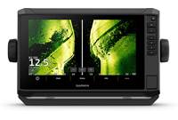
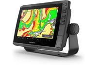
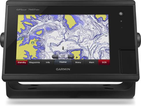
Overview: The Garmin GPSMAP 7607xsv is a Chartplotter/Sonar combination with a widescreen 7" multi-touch display. It has preloaded coastal charts and inland maps so you can navigate your vessel to your favorite fishing spots. Its built-in GPS updates your position and heading 10 times per second. If you add an optional sonar transducer (sold separately), the 7607xsv can display photo-like underwater images of fish and structure. The chartplotter is compatible with NMEA 2000 and the Garmin Marine Network for additional capabilities, such as radar, instruments, thermal cameras, and SiriusXM Marine. The unit has a water rating of IPX7, and can withstand being splashed with water without worry, but unsuitable for prolonged immersion.
Display: The GPSMAP 7607xsv features a 7" (diagonal) multi-touch color WVGA display with a resolution of 800 x 480 pixels. All of the controls are on-screen, except for the power button. The multi-touch screen lets you swipe with your finger to pan or scroll, tap the screen to select an item, and pinch or spread two fingers to zoom out or in.
Mounting: The display/control unit is approximately 8-5/8"W x 5-9/16"H x 2-5/8"D, and can be mounted a number of ways. The unit comes with a bail mount with a frame that is mounted to a flat surface with 4 screws. On the bail mount, the display/control unit can be tilted to any angle you desire. The unit can also be flush mounted, using the supplied template, rubber gasket, trim pieces, and flush-mounting hardware.
Memory Card Slots: The GPSMAP 7607xsv has two slots for microSD memory cards right on the front panel. Optional map cards allow you to view high-resolution satellite imagery and aerial reference photos to give you a "bird's eye" view of ports, harbors, marinas, and other points of interest. Blank memory cards can be used to record sonar data and transfer data (waypoints, routes, tracks, etc.) to other compatible Garmin chartplotters or your computer.
Wi-Fi Capability: The unit is capable of creating a wireless network for connecting other wireless devices. Connecting wireless devices allows you to use Garmin apps, such as BlueChart Mobile and Garmin Helm. Garmin Helm lets you view and control the unit from your smartphone or tablet. You can also connect wireless remote controls to the chartplotter.
SOS Calling: With a Garmin NMEA 2000-compatible VHF radio connected to the GPSMAP 7607xsv, you can easily initiate an SOS distress call from the chartplotter. When the SOS is marked, you can select the type of SOS (man overboard, piracy, etc.) and the chartplotter will set a direct course back to the location.
Chartplotting Features
Chart Views: The GPSMAP 7607xsv has BlueChart g2 US Coastal charts and US LakeVü HD Maps. The display will let you view these maps in several ways:
- Navigation Chart: This view shows the navigation data on the included maps with details including buoys, lights, cables, depth soundings, marinas, and tide stations in an overhead view.
- 3D Chart: The 3D chart provides a view from above and behind your vessel, and provides a visual navigation aid. This view is helpful when navigating tricky shoals, reefs, bridges, or channels, as well as entry and exit routes in unfamiliar harbors.
- Fishing Chart: The Fishing Chart provides a detailed view of the bottom contours and depth surroundings. Navigational data is removed, and the bottom contours are enhanced for depth recognition. It is best for offshore deep-sea fishing.
- Other Views: With some premium charts, you can use the Mariner's Eye 3D view for more detailed, 3-dimensional representations of your location. The Fish Eye 3D view shows an underwater view with greater detail of the sea floor, according to the chart information. With an optional sonar transducer, you can see suspended targets (such as fish) indicated as bright colored spheres.
Built-in GPS/GLONASS: The unit is equipped with a 10Hz GPS/GLONASS receiver that refreshes your position and heading 10 times per second.
Waypoints: You can mark and save up to 5000 waypoints into the unit's memory. Waypoints can be marked at your present location, or you can enter the coordinates to a waypoint at a different location. Each waypoint can be saved with a name, symbol, depth, and comments. Once a waypoint has been saved, you can select and navigate to its location. You can also measure the distance to the waypoint on the Waypoint Map.
Routes: A route is a sequence of waypoints or locations that leads you to your final destination. You can create and immediately navigate a route on the Navigation chart or the Fishing chart, or create a route by putting together a series of waypoints and turns.
Tracks: A track is a recording of the current path of your boat. You can designate a color for each track to differentiate them from each other. Tracks are created by automatically marking the current location at a set interval. The interval can be adjusted--recording more frequent plots increases accuracy, but fills up the track log quicker. You can also record tracks by the distance between points, or the variance from your course.
Boundaries: Boundaries allow you to remain in or avoid designated areas in a body of water. You can set up an alarm to alert you when you enter or exit a boundary. Boundaries can be areas, lines, or circles on the map. Saved tracks and routes can also be converted into boundary lines.
Sonar Features
Sonar Requirements: The Garmin GPSMAP 7607xsv is compatible with optional Garmin transducers, allowing it to be used as a fishfinder. Sonar views are dependent upon the type of transducer connected. The unit is compatible with traditional HD-ID, CHIRP, Panoptix, CHIRP DownVü scanning, CHIRP SideVü scanning sonar. Sonar transducers can be mounted in-hull, through-hull, kayak in-hull, or on the transom or trolling motor.
Sonar Views: There are several different sonar views (depending upon the capability of the connected transducer):
- Traditional Sonar View: The traditional view shows a large image of the sonar readings from the transducer, with depth information, suspended targets (fish), and the bottom of the body of water. Traditional sonar casts a conical beam.
- DownVu Sonar View: DownVü scanning sonar provides clearer views than traditional sonar, with photo-like images and greater detail of underwater structures. DownVü sonar emits a narrow beam, like that of a copy machine.
- SideVu Sonar View: SideVü scanning sonar shows objects in great detail that are located to the side of the boat.
- Split-Zoom View: The Split-Zoom view lets you see a full graph of sonar readings on one side of the screen, with a magnified portion of that graph on the other side of the screen.
- Split-Frequency View: The Split-Frequency view shows a full-view graph of high frequency sonar data, while the other side shows the lower frequency sonar data in a full view.
- Panoptix Sonar View: With a Panoptix-compatible transducer, you will be able to see all around the boat in real time, watch your bait underwater, and bait schools in front of, or below, your boat. LiveVü and RealVü 3D sonar views provide live, realistic views of what's around your boat.
Loading...
Loading accessories...
Customer Q&A
Loading...
Loading articles...