


About the Garmin dēzl™ 560LMT

Garmin talked to large-vehicle drivers about the unique challenges they face on the road, then designed the dezl 560LMT portable navigator for truck and RV guidance. It features a free traffic-information service that lets you know about congestion in your area so you can find a better route. You can keep up on road changes with up to four map updates per year without any additional costs. It'll get you through the long haul without endangering your cargo and it works great in your car, too.
Be the envy of your convoy
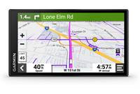
Tired of looking at a small screen from the driver's seat? The dezl 560LMT features a 5" touch display which gives you plenty of map detail. You'll have access to road maps for the entire U.S. and Canada, plus much of Mexico. Truck-specific points of interest will come in handy when it's time to find a shower or weigh station. Text-to-speech voice prompts say the actual names of roads at upcoming turns, and you'll hear them easily over engine noise through the extra-loud built-in speaker. You'll also get lane assistance and junction view to keep you in the right lane when you're at complicated intersections.
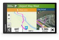
Worried about possible dangerous road conditions? The 560LMT provides upcoming road info, such as sharp curves and high winds. You'll also get a heads-up for steep grades so you can downshift accordingly. If you're in an area with a lower speed limit for trucks, the 560LMT will alert you on the screen to help you avoid an encounter with smokey. And it's got a rear-view camera input so you can see what's going on behind you when you're backing up.
Over-the-road ready
The dezl 560LMT includes a preloaded NTTS Breakdown Directory so you can find a truck repair shop nearby in case of rig trouble. It even provides 24-hour road service listings for late-night truck emergencies.
The dezl 560LMT also provides specialized routing for truck-related restrictions on most roads in the contiguous 48 states and Canada. You can specify height, weight, length, width, and hazardous materials criteria, and the navigator will provide the best, safest route to your destination — RV owners can do the same. The 560LMT also tracks your HOS (Hours of Service) and logs your mileage by state for IFTA purposes.
Don't let traffic keep you from your next pickup or drop
The dezl 560LMT includes a FM-TMC traffic-info receiver which keeps you updated on potential delays in most metropolitan areas. The 560LMT can offer detailed information on the cause of the delay, and save you time by finding a quick way around the problem. Best of all, you pay no subscription fees for the life of your navigator.
Stay connected with Bluetooth®
The dezl 560LMT's built-in Bluetooth connectivity allows you to conduct phone calls hands-free with your compatible phone. You can keep in touch with friends and family without diverting your attention from the road ahead. Most points of interest in Garmin's database include the phone numbers, so you can call ahead with the one tap of the screen to make reservations at hotels or check parking availability at truck stops.
Product highlights:
- portable GPS navigator for over-the-road trucks and RVs
- nüMaps Lifetime download card (receive up to 4 map updates per year without additional fees)
- includes FM-TMC traffic receiver for free lifetime traffic info
- JPEG picture viewer
- rear-view camera input
- portable friction mount, car power adapter, USB cable, and built-in rechargeable battery with up to 4 hours of life
Navigation features:
- 5" (480 x 272 pixels) display with touchscreen control
- 6 million points of interest (allows custom points of interest)
- maps of the United States, Canada, Puerto Rico, and U.S. Virgin Islands, plus much of Mexico (highways, secondary roads, and some cities)
- text-to-speech voice prompts announce actual road names at turns
- built-in NTTS Breakdown Directory
- allows truck-specific restrictions when routing in the contiguous 48 states and Canada
- automatic IFTA mileage and HOS tracking
- myTrends predicts your destination and automatically provides estimated arrival time
- trafficTrends provides routes based on actual historic travel times due to daily traffic
- ecoRoute calculates a more fuel-efficient route
- lane assistance and junction view
- speed limit indicator
- built-in travel kit including world clock, currency and measurement converters, calculator, and more
- security feature allows you to disable most functions with a user-entered password
- multi-destination routing: route optimization
- transport modes: truck, RV, auto, pedestrian
Expandability:
- microSD card slot
Other features and specs:
- Bluetooth technology: conduct hands-free calls with your compatible cell phone
- dimensions: 5-7/16"W x 3-5/16"H x 5/8"D
- weight: 6.8 oz.
- warranty: 1 year
- MFR # 010-00897-01
What's in the box:
Garmin dēzl™ 560LMT owner's manual
- Widescreen GPS navigator for truckers
- Mounting cradle
- Friction-type mounting base
- Mounting arm
- 19" USB cable (with Type A USB connector on one end and a micro-USB connector on the other end)
- GTM 35 FM TMC Traffic receiver/cigarette lighter power adapter (with 5' cable terminated by a USB type-B connector)
- Quick Start Manuals (Eng/Spa)
- Important Safety and Product Information booklet
- Accessory Guide
- Free Trial update for your safety cameras
- "Activate your Lifetime Maps" note
Customer reviews for Garmin dēzl™ 560LMT
Loading...
Loading reviews...
Average review:
4.0 out of 5 starsThanks for submitting your review
Customer photos


This review was collected as part of a promotion
Pros:
Cons:

More details on the Garmin dēzl™ 560LMT

Features & specs
| Features | ||
|---|---|---|
| Maps | Free lifetime updates | |
| Map Coverage | USA (50), CA, MX | |
| Points of Interest | 6,000,000 | |
| Multiple Destination Routing | Yes | |
| Screen Size | 5" | |
| Bluetooth Capable | Phone | |
| Text To Speech | Yes | |
| Voice Control | No | |
| Traffic Information | FM-TMC | |
| Dynamic Content Services | None | |
| Removable Memory Type | microSD card | |
| Battery Life | 4 Hours | |
| Warranty | ||
| Parts Warranty | 1 Year | |
| Labor Warranty | 1 Year | |
Product Research
Navigation Features
Traffic Information
Picture Viewer
Built-in Bluetooth
Mounting Options
Power Requirements
Computer Requirements
Trucker Friendly
OTR (On The Road) Navigation: The Garmin dezl 560-LMT was designed by truckers for truckers, with features that are tailored to the OTR (On The Road) trucking industry.
Custom Truck Profiles: You can enter data about the rig you're driving (such as width, overall length, height, gross weight, maximum weight per axle, and number of trailers) or what you're hauling (hazardous materials like explosives, compressed gases, flammable liquids or solids, corrosives, etc.). Multiple truck profiles can be stored in the memory.
Warning Icons: With your truck profile entered, the dezl 560-LMT will display warning icons along your route that affect your travel. Warnings include size/weight restrictions, hazmat restrictions, road conditions (grounding risk, lateral wind, narrow road, sharp curves, steep grades), and upcoming weigh stations.
Truck Speed Limits: Trucking speed limits appear if they are lower than the posted automotive speed limit, and you have the ability to correct the speed limit on the dezl 560-LMT so you have the most accurate data at all times.
NTTS Breakdown Directory: The NTTS (National Truck & Trailer Services) Breakdown Directory is pre-loaded into the unit. The dezl 560-LMT combines National Truck and Trailer Services (NTTS) Breakdown Directory POIs with Navteq trucking POIs to provide you the most comprehensive, trucking-specific POI list. You can search for truck-related points of interest, such as truck repair facilities, including those with 24-hour service.
Exit Services: The Exit Services function lets you search roadway exits for truck stops, food, lodging, rest areas, and weigh stations so you are never left guessing what is around the bend.
IFTA Logging: You can use IFTA Logging to archive data needed for International Fuel Tax Agreement documentation, such as fuel-purchase data and miles driven.
Jurisdiction Summary: The jurisdiction summary lists data for each state or province in which your vehicle has operated during each quarter. The jurisdiction summary is only available in some areas.
Hours Of Service: You can use the Hours Of Service feature to record your working hours, which will help you comply with safety regulations. You can record the following hours of service.
- Off Duty: Record the time you are off duty.
- Sleeper: record the time you are resting in the sleeper.
- Driving: Record the time you are driving a commercial motor vehicle in operation.
- On Duty: Record the time you are on duty, but not driving a commercial motor vehicle.
Trip Reports: You can conveniently export all the device's trucking logs for improved reporting and tracking of each trip. The unit's trucking logs can be stored on the unit's internal memory or external microSD card (sold separately).
Backup Camera Compatible: The dezl 560-LMT features a 3.5mm video input on its mounting cradle. If a composite video backup camera has been installed in your truck, you can view the output of the camera on the dezl 560-LMT. Simply plug the backup camera into the unit's 3.5mm video input. You will need a composite-to-3.5mm video cable (sold separately). The camera output will appear whenever a video signal is present.
Navigation Features
GPS High-Sensitivity Receiver: The Garmin dezl 560-LMT is equipped with a high-sensitivity WAAS-enabled GPS receiver which enables faster GPS performance. It must acquire a GPS (Global Positioning System) satellite signal in order to navigate.
Built-in GPS Antenna: The unit has a built-in antenna in its top panel. In order to obtain an optimal signal, the unit must have a clear, unobstructed view of the sky. If the unit is mounted in a truck with a coated windshield or an in-screen heating system, there may be difficulty in obtaining a good signal.
Pre-loaded NAVTEQ Maps: The Garmin dezl 560-LMT comes pre-programmed with NAVTEQ's City Navigator (NT 2011.31 ALL) street maps for the entire United States (including Alaska & Hawaii), Puerto Rico, Virgin Islands, Canada, and Mexico. The maps feature nearly 6-million points of interest (POIs), such as hotels, restaurants, gas stations, ATMs and attractions.
Free Lifetime Map Updates: The Garmin dezl 560-LMT includes free lifetime map updates which give you the most up-to-date maps for the life of the Garmin GPS unit. You can activate your free lifetime map updates service at www.mygarmin.com and download up to four map updates per year as soon as they become available. It can only be used for this Garmin GPS unit.
Touchscreen Display: The unit features a bright, 5.0" (diagonal) widescreen, WQVGA, color TFT LCD with touchscreen controls. The display has a resolution of 480 x 272 pixels and a 16:9 aspect ratio. The screen has a manual brightness adjustment. You can select one of three color modes for the display screen:
- Daytime: Has a lighter, brighter background.
- Nighttime: Has a black background, easier to see at night.
- Auto: Display automatically switches between daytime and nighttime at sunrise and sunset.
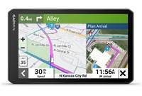
Navigation Map: The Garmin dezl 560-LMT displays a real-time moving map illustrating your current position and intended route. It will show map scale and geographic details such as lakes, rivers, highways and towns. Your route is marked with a magenta line. A checkered flag marks your destination. As you travel the dezl 560-LMT guides to your destination with arrows on the map and directions at the top of the screen. During your calculated route, your arrival time is displayed in the lower left corner, your current speed is shown in the lower right corner. The posted speed limit for most major roads is displayed near the lower right corner as well. The unit allows you to zoom, pan, and point using the touchscreen during navigation. You can select one of three map orientation displays:
- 2D Track Up: Two-dimensional map that constantly displays the route from bottom to top of the screen.
- 2D North Up: Two-dimensional map that constantly displays North at the top of the screen.
- 3D Track Up: Three-dimensional map that constantly displays the route from bottom to top of the screen.
Text-to-Speech Audible Directions: In addition to the visual map, you get voice-prompted, turn-by-turn directions that speak street names to your destination; allowing you to keep your eyes more comfortably on the road. The dezl 560-LMT offers male and female voices of various languages. You can also download custom voices from the "Garmin Garage" website.
Turn List: When you are navigating a route, the turn list displays turn-by-turn instructions for your entire route and the distance between turns.
Next Turn: When you are navigation a route, you can view the next turn on the map and the distance and time left before you reach the turn.
Lane Assist with Junction View: Lane assist with junction view guides you to the correct lane for an approaching turn or exit, making unfamiliar intersections and exits easy to navigate. It realistically displays road signs and junctions on your route along with arrows that indicate the proper lane for navigation. As you navigate your route, the unit will provide detailed diagrams of the proper lane to travel when maneuvering a complex interchange. The Junction View page will display what the actual approaching junction looks like, and arrows indicating the lane in which you should be driving.
Where Am I?: The "Where Am I?" feature gives you instant access to important information in case of an emergency. When you select "Where Am I?" from the menu, you get the coordinates (including elevation) of your current position, plus the nearest address and intersections. There are also buttons to help you locate the nearest hospitals, police stations, gas stations, and roadside assistance. You can also save the location for future reference.
Where To?: During navigation, you can search for places by pressing "Where To?" You can select an Address, Go Home, Points of Interest, Recently Found, Favorites, Extras, Intersections, Cities, Browse Map, and Coordinates. You can also access Spell Name for direct entry of your new destination, or browse the map. You can search for locations near your present location (default), or select a different city, your current route, or your destination.
| Destination Search | Description |
|---|---|
| Browse Map | Search for a destination by scrolling the map display |
| Go Home | Store and easily recall your home address |
| Address | Enter a specific address; state, city, street number, street |
| Cities | Search For a city (central location) |
| Intersections | Search for the intersection of two roads |
| POIs | Search for points of interest (POIs) by name or category; search near your current location, in a specific city, along your current route, or near your destination |
| Parking | Find parking-lots and parking garages near you; the device also saves your parking spot when your remove the device from the mount so you can find your truck easier when you return |
| Trip Planner | You can use Trip Planner to create and save a trip with multiple destinations (up to 15) |
| Favorites | Store up to 1,000 of your favorite locations |
| Recently Found | Stores the last 50 places found |
| Coordinates | Enter geographic coordinates (latitude & longitude) |
| Extras | Add extra information via a microSD card; custom points of interest, Garmin Travel Guide, Safety Camera information, TourGuide, Language Guide, and SaversGuide available on Garmin's website |
Transportation Modes: The Garmin dezl 560-LMT offers four transportation modes for navigation methods. It can be used in one of four transportation modes: Truck, RV, Automobile, or Pedestrian. Routing is calculated differently based on your mode.
Vehicle Icons: The default on-screen icon representing your vehicle is Red tractor trailer. a blue sports car. In the menu, you can select a blue tractor trailer, green tractor trailer, RV, blue 4WD pickup truck, blue compact car, blue sports car, blue 3D arrow, a pair of boots, a large bird, or a rolling beach ball. You can also download other vehicle icons from the "Garmin Garage" website.
Route Preferences: When calculating a route, you can select the following preferences: faster time, shorter distance, less fuel, or off road.
Avoidances: You can program the unit to avoid certain things that may be undesirable on your route. Examples of things that can be avoided include U-Turns, Highways, Toll Roads, Carpool Lanes, Unpaved Roads, and Ferries. You can also add Custom Avoidances for certain areas and roads.
Waypoints: You can manually add additional points (up to 1000) to your active route.
Custom Points of Interest: The dezl 560-LMT will accept custom points of interest (POI) databases, available from various companies on the Internet. Some custom POI databases contain alert information for points such as safety cameras and school zones, and the unit can notify you as you approach one of these points. To download custom POIs, you will need the Garmin POI Loader software, available on Garmin's website.
nuRoute Technology: The dezl 560-LMT includes nuRoute technology with trafficTrends historical traffic and myTrends predictive routing.
- myTrends: The myTrends feature senses when you are driving to a common destination and displays the destination and estimated time of travel in the navigation bar on the map. When you save your regular destinations in your "Favorites," the dezl 560-LMT will, over time, begin to figure out where you're going even without your telling it.
- trafficTrends: When the trafficTrends feature is enabled, the dezl 560-LMT uses historic traffic information to calculate more efficient routes. The dezl 560-LMT automatically learns daytime trends for traffic flow to improve your routes and better predict your estimated time of arrival based on time of day and day of week. Different routes may be calculated base based on traffic trends for the day of the week or based on the time of day.
ecoRoute: The ecoRoute feature calculates your truck's fuel economy, carbon footprint, and the fuel price of navigating to a destination. It also offers tools for improving fuel efficiency. Through ecoRoute's Fuel report and Mileage Report, you can track fuel usage and gas mileage during each trip. There is also a driving challenge to help you maximize your fuel economy by scoring your driving habits.
Speed Limit Indicator: The Garmin dezl 560-LMT will display the speed limit for most major roads in the United States.
Trip Computer: The trip computer provides helpful statistics about your trip.
- Shows current compass heading while moving
- Indicates current speed, maximum speed, arrival time, distance and time to next turn
- Calculates driving time, stopped time and total time
- Displays overall distance traveled (odometer) and distance to your final destination
Auto Reroute: If you deviate from the original route, the dezl 560-LMT recalculates the route and provides new directions.
Detours: While navigation a route, you can use detours to avoid obstacles ahead of you , such as construction zones.
Indoor Use: When indoors, you can activate the built-in simulator and practice using the unit. This turns off the GPS receiver so it's not searching for satellites.
Tools: The dezl 560-LMT offers several tools you can use as you travel.
- World Clock: The world clock allows you to display the current time for four locations throughout the world. You can also display a map of the world showing which portions are in daylight and which are in darkness.
- Unit Converter: You can convert distance, speed, area, currency, temperature, volume, and weight.
- Calculator: The calculator allows you to perform simple arithmetic.
Security Settings: The Garmin dezl 560-LMT offers two security settings.
- Garmin Lock: This anti-theft feature disables the unit from performing any functions until you type in a specific 4-digit PIN or take the unit to a predetermined location.
- Safe Mode: With the Safe Mode turned on, functions that require significant operator attention are disabled so they don't become a distraction while riding.
Traffic Information
FM Traffic Receiver: The Garmin dezl 560-LMT features an integrated FM traffic receiver with free lifetime traffic updates. The integrated traffic receiver is built into the unit's included cigarette lighter power adapter (GTM35). The integrated traffic receiver lets you receive alerts about traffic delays and road construction that lie ahead on your route. You can simply tap the unit's touchscreen to view traffic details or detour around the problem area. The built-in FM traffic receiver provides you with the following features and convenience.
- Receive location-based, detailed traffic information for your route when you need it (no more waiting for the local traffic report).
- Save gas and money by taking the most efficient route to avoid traffic.
- Route around delays, gridlock, and traffic jams to save you valuable time and arrive stress-free.
Traffic Map: The traffic map shows color-coded traffic flow and delays on nearby roads. When receiving traffic information, a traffic icon appears on the map. The traffic icon changes color (Green/Yellow/Red/Gray) to indicate the severity of traffic conditions.
Calculating Traffic Route: When calculating your route, the dezl 560-LMT examines the current traffic and automatically optimizes the route for the shortest time. If a severe traffic delay occurs on your route while you are navigating, the device automatically recalculates the route for your.
Mini USB Connector: The dezl 560-LMT's traffic receiver/12-volt adapter plugs into the unit's mini-USB (type-B) port, located on the back-panel of the device's mounting cradle.
Picture Viewer
microSD Memory Slot: The dezl 560-LMT has a microSD memory slot for additional map data from optional microSD memory cards. The unit can also display JPEG photo images from a microSD memory card.
Picture Viewer: The dezl 560-LMT can display photo images (JPEG files). JPEG image files stored on your computer must be transferred to the unit's internal memory.
Photo Navigation: You can upload onto the dezl 560-LMT or inserted microSD card pictures that include location information and create routes to the pictured locations. Please visit http://connect.garmin.com/photos for more information.
Built-in Bluetooth
Bluetooth Technology: Bluetooth wireless technology establishes a wireless link (2.4GHz) between two electronic devices, such as your Bluetooth enabled mobile phone and the Garmin dezl 560-LMT. The first time you use two devices together, you must pair them by establishing a relationship using a PIN or passkey.
Hands-Free Communication: For hands-free calling, the Garmin dezl 560-LMT integrates Bluetooth wireless technology with a built-in microphone and speaker. Simply pair it with your Bluetooth enabled cell-phone and talk hands-free through the 2360-LMT while staying focused on the road. You are able to dial numbers with the dezl 560-LMT's touchscreen keypad to make a call. To answer calls, just tap the touchscreen and speak into the unit's built-in microphone. The dezl 560-LMT also offers convenient one-touch dialing for contacts and points-of-interest (POIs). In addition, the dezl 560-LMT supports call waiting.
Bluetooth Compatibility: Visit http://my.garmin.com/bluetooth/phones.faces for a complete list of Bluetooth compatible mobile phones.
Mounting Options
Friction Mount: The unit should be securely installed when used in your truck. The unit comes with a friction mount which is weighted and features a non-skid mounting surface. The friction mount can be placed on your dashboard or console of your truck. Once the dezl 560-LMT is mounted, it can be rotated left-or-right on the ball-&-socket bracket for best visibility. The unit must be installed where it has a relatively unobstructed view of the sky.
Power Requirements
Power Source: The Garmin dezl 560-LMT operates on your truck's battery using the included 12-volt cigarette lighter power adapter, the built-in Lithium-Ion battery, or household current using an optional AC adapter (sold separately). The integrated Lithium-Ion battery provide up to 4 hours of use after a 4-hour charge.
Battery Charging: The integrated Lithium-Ion battery can be charged using the included 12-volt cigarette lighter power adapter in your truck, plugging the supplied USB cable into your computer, or connecting the optional AC power adapter (sold separately).
Sleep Mode: You can use the Sleep Mode to conserve battery power when the device is not in use. Sleep Mode uses very little power, and a battery charge can last for weeks.
Computer Requirements
Internal Memory: The dezl 560-LMT comes with an internal memory for storage of supplemental maps and photos. When the unit is connected to your computer, the dezl 560-LMT is recognized as a USB Mass Storage device.
Interface Capability: This unit is connected to a PC via the supplied USB cable for software and navigation updates. This interface allows you to download additional map and software information to the unit's flash memory or inserted microSD card.
Garmin Express: You can connect the unit to your computer with the supplied USB cable for downloading map updates, custom POIs, voices, and vehicles. You will need to download the Garmin Express software to update your maps and register the unit. Garmin Express requires Windows Vista or newer or Mac OS X 10.7 or higher, running in 64-bit.
Loading...
Loading accessories...
Customer Q&A
Loading...
Loading articles...

Over all the GPS works Great. minor glitches like posted speed limit and displayed limit are not accurate. and to pan ahead and view the rest of the map is not an option. Bluetooth works great speaker works great Screen size is perfect. A must buy for any trucker!
KostaM from Rockaway Park, NY