

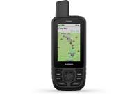
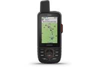


About the Garmin GPSMAP 78SC

Explore coastal waters and more
Explore coastal waters and more

Relax, it's waterproof....
Garmin designed the GPSMAP 78sc for boaters and outdoor enthusiasts who want a powerful navigation device that's slim, lightweight, and ready for adventures on the water or on land. It even floats!
The rugged GPSMAP 78sc comes with built-in BlueChart® g2 coastal charts and a worldwide basemap with imagery — perfect for all your outdoor pursuits. It also features a 3-axis compass, barometric altimeter, crisp color mapping, a high-sensitivity receiver, new molded rubber side grips. Map detail includes shorelines, depth contours, navigational aids, harbors, marinas and more for the U.S. and Bahamas. With its high-sensitivity, WAAS-enabled GPS receiver and HotFix™ satellite prediction, the GPSMAP 78sc locates your position quickly and maintains its GPS location even in heavy cover.
Get your bearings
GPSMAP 78sc includes a built-in 3-axis tilt-compensated electronic compass, which shows your heading even when you're standing still, without holding it level. Its barometric altimeter tracks changes in pressure to pinpoint your precise altitude, and you can even use it to plot barometric pressure over time. That helps you keep an eye on changing weather conditions, which is a big benefit on land or water.
Get connected
After a busy day of exploring, you can connect this Garmin to your laptop and visit the Garmin Connect™ website for a detailed analysis of your activities. This site offers an activity table and allows you to view your activities on a map using Google™ Earth. You can explore routes uploaded by other Garmin Connect users, and share your experiences on your favorite social media platforms. The GPSMAP 78sc also supports geocaching GPX files for downloading geocaches and details straight to your unit.
With GPSMAP 78sc, you can also share your waypoints, tracks, routes and geocaches wirelessly with other compatible device users. Just press "send" to share the location of your favorite fishing spot with a friend.
Need more maps?
The GPSMAP 78sc uses a built-in microSD™ card slot for loading Garmin's wide array of detailed marine, topographic and road maps. You can also plug in BlueChart® g2 preloaded cards for a great day on the water or City Navigator NT® map data for turn-by-turn routing on roads. The card slot is located inside the waterproof battery compartment, so you don't have to worry about getting it wet.
The GPSMAP 78sc also supports BirdsEye™ Satellite Imagery (subscription required), that lets you download satellite images to your device and integrate them with your maps. In addition, this handheld is compatible with Custom Maps, free software that transforms paper and electronic maps into downloadable maps for your device.
Product highlights:
- designed for boating, watersports, and outdoor activities
- built-in BlueChart® g2 coastal charts and a worldwide basemap
- wireless data sharing with compatible devices
- turn-by-turn routing on roads
- built-in altimeter
- 65K color display (160 x 240 pixels)
- store up to 2000 waypoints and 200 routes
- navigate to geotagged photos
- includes tide tables, sun/moon info, and hunting/fishing calendar
- compatible with Garmin Connect™
- high-speed USB and NMEA 0183 compatible
- 1.7 GB internal memory
- accepts optional microSD cards
- waterproof rating: IPX7
- display size: 1.43" x 2.15" (3.6 x 5.5 cm); 2.6" diag (6.6 cm)
- dimensions: 2.6" W x 6" H x 1.2" D (6.6 x 15.2 x 3.0 cm)
- requires 2 AA batteries (not included)
- warranty: 1 year
- MFR # 010-00864-02
What's in the box:
Garmin GPSMAP 78SC owner's manual
- Hand-held marine GPS
- Wrist strap
- 19.5" USB cable (Type A USB on one end and Mini-B USB 2.0 on other end)
- Quick Start Manual (English)
- Quick Start Manual (French)
- Specialized maps for land and sea (brochure)
- Important Safety and Product Information
- Getting Your Manuals from the Device sheet
Customer reviews for Garmin GPSMAP 78SC
Loading...
Loading reviews...
Thanks for submitting your review
Customer photos


This review was collected as part of a promotion
Pros:
Cons:

More details on the Garmin GPSMAP 78SC

Product Research
Features
Overview: The Garmin GPSMAP 78SC is a hand-held GPS designed for use on or near the water. This IPX7 waterproof navigator includes BlueChart g2 coastal charts and a worldwide basemap. It also has a microSD card slot for optional maps, such as topo maps or highway maps for your travels on land. It is powered by two "AA" batteries (not included).
GPS Receiver: The unit has a high-sensitivity, WAAS-enabled GPS receiver which lets you quickly locate your precise location within 10-to-16 feet. HotFix satellite prediction helps the unit maintain your GPS location, even when your overhead view is restricted.
Compass/Altimeter: The GPSMAP 78SC is equipped with a 3-axis electronic compass that is accurate to within 2 degrees. The compass is tilt-compensated, showing your heading without having it hold it level. The bearing pointer appears as a red arrow at the top of the compass screen when you are traveling directly toward your destination. The unit also has a built-in altimeter that is accurate to within 10 feet. It can indicate your altitude in 1-foot increments up to 30,000 feet.
Sight 'N Go: The Sight 'N Go function lets you point the device at an object in the distance, lock in the direction, then navigate to that object.
Display: The device has a 2.6" vertically-oriented, 160 x 240-pixel, backlit TFT 65K color display. It is not a touchscreen display.
Included Maps: The GPSMAP 78SC comes with the BlueChart US Marine Detail g2 maps (v2013.0), as well as the worldwide DEM basemap. You can purchase additional maps on microSD cards, such as City Navigator NT, to give you turn-by-turn routing on roads or topographical maps for exploring on land.
Geocaches: If you are active in Geocaching, you can connect the unit to the Internet via your computer and download the coordinates. The unit has a Geocaches menu position where you can find your downloaded Geocaches and navigate to them.
Data Storage: The unit has a built-in memory of approximately 1.7 GB. A microSD card slot is provided inside the battery compartment for additional maps or data storage.
Wireless Data Sharing: The GPSMAP 78SC will let you wirelessly share Waypoints, Routes, Tracks, or Geocaches to another device. The data is transferred via 2.4GHz/ANT+ protocol to another compatible Garmin device within 10 feet.
Water Resistance: The GPSMAP 78SC is designed for use on or near the water. It is made of high-impact plastic alloy, so it can withstand rough treatment. The rubberized side grips let you keep a firm grasp of the device, even in wet conditions. The fully-gasketed navigator meet IPX7 standards, and is waterproof to withstand accidental immersion in one meter of water for up to 30 minutes.
Power Requirements: The GPSMAP 78SC operates on alkaline, Lithium, or rechargeable Ni-MH batteries. Alkaline batteries can fail in temperature extremes, and it is recommended that Lithium batteries be used in below-freezing temperatures. Battery life is approximately 20 hours with typical usage.
Connections: The unit has three connectors under a water-resistant cover:
- MCX: The MCX connector allows you to connect an external GPS antenna, such as the GA 25MCX Low Profile GPS antenna.
- USB: The Mini-B 2.0 USB port lets you connect to your computer with the supplied USB cable.
- Serial Port: This 4-pin serial port is designed specifically for use with the Garmin A/C PC Adapter (item 010-10277-00). It connects the device to A/C power and to your computer.
Additional Tools: For convenience, the GPSMAP 78SC has several tools that you can use:
- Calendar: for checking dates at a glance
- Calculator: for calculating basic math functions
- Sun and Moon: displays sunrise and sunset times, and moon phases
- Alarm Clock: you can set an audible alarm, or to turn the device on at a specific time
- Hunt and Fish: displays the predicted best dates and times for hunting and fishing at your current location
- Stopwatch: perform basic stopwatch functions, including marking and timing laps
- Waypoint Averaging: allows you to refine a waypoint location with multiple samples for the most accurate location
Loading...
Loading accessories...
Customer Q&A
2 questions already asked
Loading...
Loading articles...