


About the Garmin nüvi® 52

Let Garmin lead the way
Let Garmin lead the way
Garmin's nüvi 52 portable navigator provides reliable guidance almost anywhere in the U.S., and on many major Caribbean islands. You'll enjoy access to detailed maps and millions of preloaded points of interest for important stops along the way.
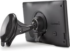
The redesigned mount allows for convenient placement of the nüvi 52 on your windshield.
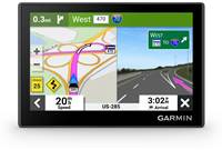
The nüvi 52's bright 5" color touchscreen display lets you see the maps more clearly, so you can follow it without squinting. The overhauled chassis features a sleeker, thinner profile, and the redesigned rear mount provides added security on your windshield.
Guidance that won't lead you astray
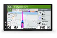
This Garmin announces actual street names at turns, so you'll hear "turn right on Hudson Street" instead of "take the next right." Colored arrows pop up as you approach complicated interchanges and junctions, showing you the the proper lane for the next maneuver. And you can check out your vehicle's speed as well as the posted speed limits on most major roads along your route to make sure you're staying safe.
Valuable extras
The "Where Am I?" emergency locator provides your exact location instantly, displaying nearby emergency services if you need aid. Garmin's trip computer lets you record mileage, maximum speed, total time, and more. Garmin's website allows you to customize your vehicle icon to add a touch of personality. The nüvi 52 also lets you assign custom points of interest so you can find favorite stops that are a little off the beaten path.
Product highlights:
- portable GPS navigator
- suction-cup windshield mount
- car power adapter, micro-USB cable, and built-in rechargeable battery with up to 2 hours of life
Navigation features:
- 5" (480 x 272 pixels) display with touchscreen control
- 5 million points of interest (allows custom points of interest)
- preloaded with maps for the United States (except Alaska) and Puerto Rico, plus U.S. Virgin Islands, Cayman Islands, Jamaica, and Bahamas
- text-to-speech voice prompts announce actual road names at turns
- lane assistance and junction view
- speed limit indicator
- trip computer
- multi-destination routing: allows 1,000 waypoints
- transport modes: auto
Expandability:
- microSD™ card slot
Other features and specs:
- dimensions: 5-1/2"W x 3-7/16"H x 13/16"D
- weight: 6.4 oz.
- warranty: 1 year
- MFR # 010-01115-00
What's in the box:
Garmin nüvi® 52 owner's manual
- Portable GPS navigation device (w/ 5.0" LCD)
- Suction-cup mount
- Mounting bracket
- Cigarette lighter/power adapter (w/ attached 5.5' cable)
- Quick Start Manual
- Important Safety/Product Information
Customer reviews for Garmin nüvi® 52
Loading...
Loading reviews...
Thanks for submitting your review
Customer photos


This review was collected as part of a promotion
Pros:
Cons:

More details on the Garmin nüvi® 52

Features & specs
| Features | ||
|---|---|---|
| Maps | Updates optional | |
| Map Coverage | USA (49), USVI, PR, Jamaica | |
| Points of Interest | 5,000,000 | |
| Multiple Destination Routing | Yes | |
| Screen Size | 5" | |
| Bluetooth Capable | No | |
| Text To Speech | Yes | |
| Voice Control | No | |
| Traffic Information | No | |
| Dynamic Content Services | None | |
| Removable Memory Type | microSD card | |
| Battery Life | 2 Hours | |
| Warranty | ||
| Parts Warranty | 1 Year | |
| Labor Warranty | 1 Year | |
Product Research
Navigation
Features
Convenience Features
Installation Options
Navigation Features
GPS Receiver: The Garmin nuvi 52 is equipped with a high-sensitivity WAAS-enabled GPS receiver and built-in antenna which enables the unit to acquire GPS (Global Positioning System) signals for on-the-road navigation.
Preloaded Maps: The nuvi 52 contains NAVTEQ's City Navigator North America NT-Lower 49 States maps (ver.2013.30) with detailed road maps of the lower 49 States (excluding Alaska), Puerto Rico, U.S. Virgin Islands, Cayman Islands, Bahamas, French Guiana, Guadeloupe, Martinique, Saint Barthelemy, and Jamaica.
Note: You can purchase additional MapSource map data from Garmin and load the maps to the nuvi 52's internal memory or inserted microSD card (via USB connection).
nuMaps Guarantee: If you register your device on Garmin's website within 90 days of acquiring satellites while driving, you can check to see if a free map update is available. You must be able to connect your device via a high-speed internet connection in order to check the loaded map version and download the map update.
Points of Interest: The built-in maps include over 5-million Points of Interest (POIs) such as hotels, restaurants, gas stations, attractions, and ATMs to help you find the destination you desire. In addition, you can download additional points of interest and add them to the unit's memory (Custom POIs). The free POI Loader software can be downloaded from the Garmin website to assist you in creating Custom POIs.
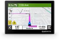
Map Screen: The Garmin nuvi 52 displays a real-time moving map illustrating your current position and intended route. It will show map scale and geographic details such as lakes, rivers, highways and towns. Your route is marked with a magenta line. A checkered flag marks your destination. As you travel the nuvi 52 guides to your destination with arrows on the map and directions at the top of the screen. If you depart from the original route, the device recalculates the route and provides new directions. During your calculated route, your direction of travel is displayed in the lower left corner and your current speed is shown in the lower right corner. The posted speed limit for most major roads is displayed near the lower right corner as well. The unit allows you to zoom, pan, and point using the touchscreen during navigation. You can select one of three map orientation displays:
- 2D Track Up: Two-dimensional map that constantly displays the route from bottom to top of the screen.
- 2D North Up: Two-dimensional map that constantly displays North at the top of the screen.
- 3D Track Up: Three-dimensional map that constantly displays the route from bottom to top of the screen.
Turn Assistant: When you are navigating a route, you can view the next turn on the map and the distance and time left before you reach the turn. You can also view the Turn List which displays turn-by-turn instructions for your entire route and the distance between turns.
Lane Assist w/ Junction View: Lane assist with junction view indicates the proper lane for a turn or exit with brightly colored arrows and detailed images.
Speed Limits: As you travel along a major road, the speed limit is displayed on the screen alongside of the vehicle's speed display. If you are exceeding the speed limit, the color of the vehicle speed indication changes to red. If the highway's posted speed limit has changed since the last map update, you can change the speed limit display on the unit.
Text-to-Speech Audible Directions: In addition to the visual map, you get voice-prompted, turn-by-turn directions that speak street names to your destination; allowing you to keep your eyes more comfortably on the road. The nuvi 52 offers voices of various languages.
Where Am I?: The "Where Am I?" feature gives you instant access to important information in case of an emergency. When you select "Where Am I?" from the menu, you get the coordinates (including elevation) of your current position, plus the nearest address and intersections. There are also buttons to help you locate the nearest hospitals, police stations, gas stations, and roadside assistance. You can also save the location for future reference.
Destination Search: When the Where To? button is pressed, you can use the search tools to find your destination and plan your route. The search tools allow you to search for cities, addresses, intersections, or coordinates. You can also search the device's POIs (points-of-interest). The unit's memory stores the last 50 locations you have found so you can quickly find a previous destination. You can even store your favorite destinations, so you can retrieve them faster. In addition, you can simply browse the map and select a destination by tapping the screen.
Route Preferences/Avoidances: When calculating a route, you can select the following preferences; faster time, shorter distance, or off road. You can also program the unit to avoid certain things that may be undesirable on your route; such as U-Turns, Highways, Toll Roads, Carpool Lanes, Unpaved Roads, and Ferries.
Waypoints: You can manually mark and name any map position as a waypoint for later recall. Up to 1000 waypoints can be saved into memory.
Trip Computer: The trip information page displays your current speed and direction, and provides helpful statistics about your trip. A trip odometer keeps up with your total mileage. The page also indicates the distance and driving time to your next maneuver, as well as the distance and driving time to your destination. Your maximum speed and moving average speed are also displayed. The information can be reset in advance of your next trip.
Auto Reroute: If you deviate from the original route, the nuvi 52 recalculates the route and provides new directions.
Detours: While navigating a route, you can use detours to avoid obstacles ahead of you, such as construction zones.
Safe Mode: With the Safe Mode turned on, functions that require significant operator attention are disabled so they don't become a distraction while driving.
Convenience Features
5.0" Touchscreen LCD: The nuvi 52 features a 5.0" color TFT touchscreen LCD with a resolution of 480 x 272 pixels (16:9 aspect ratio). The screen has a manual brightness adjustment. You can select one of three color modes for the display screen:
- Daytime: Has a lighter, brighter background.
- Nighttime: Has a black background, easier to see at night.
- Auto: Display automatically switches between daytime and nighttime at sunrise and sunset.
Keyboard Options: The Garmin nuvi 52 gives you two options for keyboard layouts. When you are entering an address or other data, you can choose between a standard QWERTY keyboard layout or an ABCDE alphabetical layout.
microSD Card Slot: The nuvi 52 has a microSD card slot so you can download and store additional mapping information from Garmin.
USB Port: The nuvi 52 is fitted with a mini-USB (type-B) port to connect to your computer (with optional cable). The nuvi 52 is compatible with Windows XP or newer and Mac OS X 10.4 or later.
Garmin Express: Use Garmin Express to keep the nuvi 52 up-to-date. Garmin Express makes it easy to update maps and software, transfer favorites to and from devices, and install free custom vehicles and voices.
Installation Options
Mounting: The Garmin Nuvi 52 comes with a suction cup mounting bracket to install the device in your vehicle. The suction cup can be used to mount the unit to your vehicle's windshield or dash. Once the nuvi 52 is mounted, it can be adjusted on the ball-and-socket bracket for best visibility. The unit must be installed where it has a relatively unobstructed view of the sky.
Note: Please check the applicable regulations in your state regarding windshield mounting. Certain states prohibit the mounting of any items on your windshield.
Power Requirements: The Garmin nuvi 52 is powered and charged by your vehicle's battery using the included 12-volt cigarette lighter/power adapter. The built-in Lithium-Ion battery will provide up to 2 hours of use after a 4 hour charge. The unit can also be charged and powered by your computer when it is connected via the included USB cable. An optional AC adapter (150ACNUVI, sold separately) allows you to operate and charge the unit on ordinary household current.
Loading...
Loading accessories...
Customer Q&A
Loading...
Loading articles...