


About the Garmin RV 660LMT

A trustworthy guide for your next cross-country trek
A trustworthy guide for your next cross-country trek
Just because you gave up a few of the "comforts" of home to hit the road in your RV, there's no reason to go without reliable guidance. Garmin's RV 660LMT portable navigator boasts RV-centric routing, accurate maps, and convenient extra features to keep you on the right path. A super-thin chassis houses the beautiful 6.1" display, which offers horizontal and vertical map displays with pinch-to-zoom capability. The navigator offers a free traffic-info service so you'll be aware of congestion along your route, as well as four free map updates per year, to ensure you're up-to-date. Voice-activated guidance lets you search for destinations safely, so you can keep your eyes on the road and hands on the wheel.
RV-friendly routing
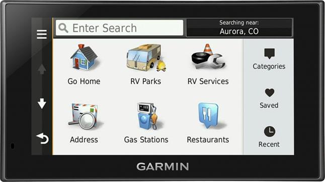
The RV 660LMT includes a database from America's RV Parks & Services Directory, giving you instant access to nearly 20,000 sites in the U.S. and Canada. You'll be able to find RV parks and campgrounds quickly, and you can narrow your search by type of amenities desired, including pet-friendly, on-site laundry, electric hookups, Wi-Fi®, and more.
The RV 660LMT also provides specialized routing for RV-related restrictions on most roads in the continental United States, Alaska, and Canada. You can specify height, weight, length, and width criteria, and the navigator will provide the best, safest route to your destination. If you're entering an area with a different posted speed limit for trucks or multi-axle vehicles, you'll get an alert for that, too. You'll also receive state border notices, sunrise/sunsets, mile marker info, and the grade of your current road.
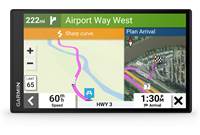
The RV 660's elevation map tool gives you info on elevation along your route while viewing the map screen. You can tap the screen for more detail about potential steep grades before you hit a hill your RV might not be ready for.
Let your fingers do the mapping
If you've spent a little too long in the wilderness, you might want to take a quick detour through the nearest town to drive on actual asphalt for a change. Rather than entering a new destination, simply use Garmin's Easy Route Shaping feature to add a point to your route onscreen by touching the map, and the RV 660 will tell you how much time the side trip will add to your overall journey before you embark.
Find it via Foursquare®
Foursquare's crowd-sourced database of points of interest breathes new life into tired directories of where to stop for gas, food, or shopping, and it adds millions of potential stops to your travels. When you look for points of interest on the RV 660LMT, you'll see the most relevant Foursquare results at the top of the search bar, so you'll know the destination is verified by actual users. If you've got your navigator paired with Garmin's Smartphone Link, you'll also see helpful info such as ratings, hours, and price range displayed on the navigator's screen. And if you're a Foursquare user yourself, you can check in nearly anywhere through the navigator when it's paired with your phone.
Roll up to the front door
Most portable navigators leave you on your own once they've gotten you to the general vicinity of your destination, which can be a real hassle when you're trying to find a specific store in a mall or the correct gate at an airport. Garmin's Direct Access feature helps you find your way to specific points at select malls, airports, and universities, taking you directly to that particular location so you don't have to search helplessly once you've gotten to the area. It'll even help you get through parking lots to get you as close to your exact destination as possible, giving business travelers an edge when it's time to rent a car.
Ear-friendly directions
The RV 660LMT offers Garmin Real Directions with Garmin Real Voice, a combination that helps keep you relaxed as you drive. Real Directions voice prompts speak the instructions to you like a friend would, using easy-to-see landmarks, buildings and businesses, and traffic lights, rather than streets with tiny signs that you might not see in time. With Real Voice technology, you'll hear directions spoken in a personable, human-sounding voice that you'll comprehend readily.
Guidance you can count on
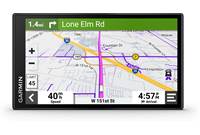
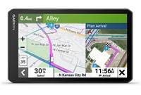
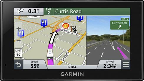
The generous high-resolution touch display shows you everything you need to know from the driver's seat. It offers detailed road maps of the entire continental United States, Alaska, Canada, and Puerto Rico, plus urban areas in Hawaii and Mexico. You'll hear text-to-speech voice prompts that say actual road names at turns, like "turn left on Mercado Way," instead of "take the next left." The navigator gives you easy-to-understand spoken directions using landmarks, buildings, and traffic lights, so you don't always have to keep an eye out for street signs.
Garmin's Active Lane Guidance feature offers regularly updated animations of your best lane option, not just when you're coming up on the next maneuver. Speed limit warnings help you drive in a conscientious manner. Realistic views of complicated intersections make it easier to get through unfamiliar areas so you can get to the relaxing parts of your journey more quickly.
This Garmin's also compatible with the optional Garmin BC 30 wireless rear-view camera, so you can add an extra layer of safety when you're backing out of your driveway.
No-touch guidance and Bluetooth®
The RV 660LMT's main guidance functions are voice-activated, so you can use your hands to keep your vehicle on course. Simply say the keyword, and you'll be able to find a nearby point of interest, establish a route, or locate a contact without touching the navigator.
The Garmin's built-in Bluetooth connectivity allows you to conduct phone calls hands-free with your compatible phone. You can keep in touch with friends and family without diverting your attention from the road ahead. Most points of interest in Garmin's database include the phone numbers, so you can call ahead to make reservations at restaurants or check availability at nearby campgrounds.
Free lifetime traffic
The RV 660LMT includes a FM-TMC traffic-info receiver which keeps you updated on potential delays in most metropolitan areas. The navigator can offer detailed information on the cause of the delay, and save you time by finding a quick way around the problem. You'll pay no subscription fees for the life of your navigator.
Add your smartphone to the mix
You can pair the RV 660LMT with your iPhone® or Android™ smartphone to take advantage of Garmin's Smartphone Link app, which allows the two devices to share information, such as saved and recently found locations, where you parked, and your current destination. You can also subscribe to dynamic services from Garmin for more road-friendly content like weather reports and fuel prices for an additional fee. Data charges may apply for using Smartphone Link — you'll want to check with your service provider.
Plan your adventures
No more wasting gas as you sit there typing in your RV — you can use Garmin's BaseCamp online tool to map out your next journey ahead of time, then upload the finished route to the RV 660LMT before you hit the road. You can mark waypoints and tracks for off-road fun whether you're into hiking, biking, fishing, or just exploring the scenery. You can also share the results of your travels with Garmin Adventures, a free way to swap GPS details with other explorers online. You can create timelines with photos and videos for your trips, and even find new paths to undertake.
Product highlights:
- portable GPS navigator for RVs
- nüMaps Lifetime subscription (receive up to 4 map updates per year without additional fees)
- includes FM-TMC traffic receiver for free lifetime traffic info
- suction-cup windshield mount, car power adapter, micro-USB cable, and built-in rechargeable battery with up to 1 hour of life
Navigation Features:
- 6.1" (800 x 480 pixels) dual-orientation display with pinch-to-zoom touchscreen control
- accepts spoken commands and voice address entry
- detailed maps of the continental United States, Alaska, Canada, and Puerto Rico, plus urban areas in Hawaii and Mexico
- includes RV-specific features such as routing for large vehicles and America's RV Parks & Services Directory
- millions of points of interest (allows custom points of interest)
- includes Foursquare points of interest
- text-to-speech voice prompts announce actual road names at turns
- allows RV-specific restrictions when routing in the continental United States (including Alaska) and Canada
- Direct Access provides door-to-door directions to destinations within select malls, airports, and universities
- Real Directions gives instructions using landmarks, buildings, and traffic signals
- Easy Route Shaping allows simple one-touch route modification
- elevation profile map tool displays possible steep grades along route
- Real Voice announces directions in human-like voice
- Active Lane Guidance with voice prmopts
- photoReal junction view
- speed limit and school zone indicators
- Up Ahead feature informs of nearby services
- multi-destination routing: route optimization
- transport modes: truck, RV, auto
Connectivity:
- Bluetooth technology allows hands-free calls with your compatible phone
- works with Garmin Smartphone Link app
- works with Garmin BaseCamp and Garmin Adventures online
Expandability:
- microSD card slot
- compatible with optional Garmin BC 30 wireless camera
Other Features and Specs:
- dimensions: 6-5/8"W x 3-3/4"H x 13/16"D
- weight: 9.5 oz.
- warranty: 1 year
- MFR # 010-01535-00
What's in the box:
Garmin RV 660LMT owner's manual
- Portable GPS navigation device for RVs (w/6" LCD)
- Universal bracket mount
- Suction cup mount
- TA20 Car charger/Traffic antenna with attached 66" cable (right-angled Mini-B 2.0 USB plug)
- 20" USB cable (Type A USB on one end and MicroUSB on the other end)
- "Welcome" sheet (graphic quick start guide)
- Important Safety and Product Information
Customer reviews for Garmin RV 660LMT
Loading...
Loading reviews...
Average review:
4.0 out of 5 starsThanks for submitting your review
Customer photos


This review was collected as part of a promotion
Pros:
Cons:

More details on the Garmin RV 660LMT

Features & specs
| Features | ||
|---|---|---|
| Maps | Free lifetime updates | |
| Map Coverage | USA (50), CA, MX, PR, USVI | |
| Points of Interest | Millions | |
| Multiple Destination Routing | Yes | |
| Screen Size | 6.1" | |
| Bluetooth Capable | Phone | |
| Text To Speech | Yes | |
| Voice Control | Yes | |
| Traffic Information | Garmin Traffic | |
| Dynamic Content Services | via Smartphone Link | |
| Removable Memory Type | microSD card | |
| Battery Life | 1 Hour | |
| Warranty | ||
| Parts Warranty | 1 Year | |
| Labor Warranty | 1 Year | |
Product Research
General Features
Navigation Features
General Features
Overview: The Garmin RV 660 LMT is a portable GPS navigation device that provides automatic routing and turn-by-turn voice directions. It is designed for recreational vehicles (RVs), and includes customized RV routing for the US and Canada. The unit includes subscription-free, lifetime traffic updates and free lifetime map updates. With built-in Bluetooth, you can make and receive hands-free phone calls through a Bluetooth-enabled phone, plus receive live services through a free Smartphone Link app.
6" Touchscreen LCD: The RV 660 LMT features a large 6" color TFT touchscreen LCD with white backlight, and a resolution of 800 x 480 pixels.
Preloaded Maps: The RV 660 LMT contains NAVTEQ's City Navigator North America NT 2015 maps. Maps includes detailed coverage of the United States*, Canada, Mexico*, Puerto Rico, US Virgin Islands, Cayman Islands, The Bahamas, French Guiana, Guadeloupe, Martinique, Saint Barthélemy, and Jamaica.
Free Lifetime Map Updates: The RV 660 LMT offers free lifetime map updates so you'll always have the most up-to-date maps, POIs, and navigation information. Map updates are available for download up to 4 times a year with no subscription or update fees and no expiration dates. Free Lifetime Map Updates are subject to Terms & Conditions.
nüMaps Guarantee: If you register your device on Garmin's website within 90 days of acquiring satellites while driving, you can check to see if a free map update is available. You must be able to connect your device via a high-speed internet connection in order to check the loaded map version and download the map update.
Garmin Express: You can connect the unit to your computer with the supplied USB cable for downloading map updates, custom POIs, voices, and vehicles. You will need to download the Garmin Express software to update your maps and register the unit. Garmin Express requires Windows Vista or newer or Mac OS X 10.7 or higher, running in 64-bit.
America's RV Parks & Services Directory: The Garmin RV 660 LMT includes data from America's RV Parks & Services Directory, a comprehensive directory of nearly 20,000 RV parks and campgrounds, and approximately 14,000 service locations in the coverage area. You can search for sites with various amenities, including hookups (full, electric, water, pull-throughs, dump stations), accessibility (pet-friendly, handicap, big-rigs), recreational (boating, fishing, swimming, cable TV, internet), and service (truck stops, towing, repairs, tires).
Customized RV Routing: The included maps feature RV-related restrictions, such as bridge heights, sharp curves, and related information for most major highways. After entering your RV's dimensions (height, weight, width, and length), the device will find routes that are suitable for your RV. While traveling, the unit will display the elevation grade of your current route.
Foursquare: The RV 660's POI database contains location information on millions of points-of-interest, including businesses, stores, restaurants, hotels, and other destinations. The database now includes information from Foursquare, a local search and discovery service, that provides personalized recommendations based on your current location.
Bluetooth: The RV 660 LMT has built-in Bluetooth technology. This allows you to sync the unit with a Bluetooth-enabled device for hands-free calling through its integrated microphone and speaker. You can make and receive phone calls as long as the devices are within 33 feet and paired.
microSD Card Slot: The RV 660 LMT has a microSD card slot so you can store and use optional cityXplorer or marine maps (available from Garmin), or download custom voices and vehicles from the Garmin Garage.
Optional Backup Camera: The RV 660 LMT is compatible with the optional BC 30 Wireless Backup Camera. The BC 30 operates on a 2.4GHz wireless system to send video to the RV 660 LMT from up to 45' away. When you put the RV in reverse, the view from the BC 30 will appear on the screen with guidance lines to assist you in backing up.
Power Requirements: The Garmin RV 660 LMT is powered by your vehicle's battery using the included 12/24-volt cigarette lighter power adapter. The built-in Lithium-Ion battery will provide up to 1 hour of use after a 4-hour charge. An optional AC adapter allows you to operate the unit on ordinary household current. The unit can be powered by your computer when it is connected via the supplied USB cable.
Navigation Features
Garmin Real Directions/Garmin Real Voice: The RV 660 LMT features Garmin Real Directions with easy-to-understand driving directions using recognizable landmarks, buildings, and traffic lights, in addition to street names. Garmin Real Voice uses advanced speech technology that sounds more like a natural human voice.
Voice-activated Navigation: You can use your voice to activate and operate the RV 660 LMT. Voice-activated Navigation allows you to use the device by speaking words and commands and following the voice prompts. After speaking a predetermined Wakeup Phrase, you can enter the names and/or address of popular, well-known locations. If necessary, you can disable voice prompts without muting the device, so you'll still hear the audible directions as you travel.
Smartphone Link: Smartphone Link is a phone application that allows the device to download live data using your phone's data connection, and transferring the data wirelessly via Bluetooth. The free Garmin Smartphone Link app provides access to Garmin Live Services, which includes free and subscription-based plans for viewing traffic data, weather, dynamic parking, and fuel prices. Garmin Smartphone Link is available for iPhone (iOS 6.0 or later) in the App Store and for Android (version 2.2 and up) in the Google Play store.
Garmin Traffic: Garmin Traffic helps you avoid traffic tie-ups that may delay your travel. It uses one of the most extensive traffic avoidance systems to check traffic conditions more than 2 billion times a month. The traffic updates appear to the side of the map, so your driving map remains onscreen at all times. The updates can give you details about the situation, including the estimated length of the delay. Free Lifetime Garmin Traffic requires no subscription or activation, and is subject to Terms & Conditions.
Optional Garmin HD Digital Traffic: When you add the optional Garmin GTM60 HD Digital Traffic receiver, you will receive updates as often as every 30 seconds over the HD Radio system, more than 20 times more often than other analog traffic receivers. Garmin HD Digital Traffic is available in approximately 125 metropolitan markets throughout the U.S.
Points of Interest: The built-in maps include millions of Points of Interest (POIs) such as hotels, restaurants, gas stations, attractions, and ATMs. are included to help you find the destination you desire. In addition, you can download additional points of interest and add them to the unit's memory (Custom POIs). The free POI Loader software can be downloaded from the Garmin website to assist you in creating Custom POIs.
Active Lane Guidance: Active Lane Guidance with voice prompts lets you know in advance which lane you should to be in to make an upcoming turn. In select metropolitan areas, the RV 660 LMT will enter split screen mode to display the photoReal junction view, a realistic depiction of the junction, complete with road signs and brightly-colored arrows to indicate the proper lane for navigation. The Bird's Eye view also gives you a top-down view of upcoming interchanges.
Map View Options: You can choose from a 3D map view or two 2D map views (Track Up or North Up) as you navigate to your destination.
Speed Limits: As you travel along a major road or street, the speed limit is displayed on the screen alongside of the vehicle's speed display. If you are exceeding the speed limit, the color of the vehicle speed indication changes to red. If the highway's posted speed limit has changed since the last map update, you can change the speed limit display on the unit.
Where Am I?: The "Where Am I?" feature gives you instant access to important information in case of an emergency. When you touch the vehicle icon on the map screen, the "Where Am I?" feature provides the coordinates (including elevation) of your current position, plus the nearest address and intersections. There are also buttons to help you locate the nearest hospitals, police stations, gas stations, and roadside assistance. You can also save the location for future reference.
Up Ahead: As you travel along your route, the Up Ahead feature constantly indicates the location of nearby businesses, including gas, food, lodging, restrooms, parking, and banks and ATMs. The locations are shown as icons, some with brand logos, and when the icons are touched on the screen, details of the services are displayed, and you are given the opportunity to navigate to that address.
Garmin Locate: To assist you in finding your parked vehicle, the Garmin Locate feature saves your location to memory when you remove the device from the windshield mounting cradle while the device is on. You can search for your vehicle's location using the Last Spot button in the menu.
Destination Search: When the Where To? button is pressed, you can use the search tools to find your destination and plan your route. The search tools allow you to search for cities, addresses, intersections, or coordinates. The new Search Bar lets you directly enter a category, brand name, address, or city name. The unit's memory stores the last 50 locations you have found so you can quickly find a previous destination.
Garmin Garage: The unit offers your choice of eight standard icons to represent your vehicle. The online Garmin Garage offers dozens more vehicle icons that you can download for free. In addition, you can purchase icon and voice bundles with Star Wars (Yoda, Darth Vader), Sesame Street (Oscar, Cookie Monster, Ernie & Bert), and The Simpsons (Homer and Marge) themes.
BaseCamp Trip Planner: You can plan your next RV trip using Garmin's BaseCamp downloadable software. The software lets you view maps, plan routes, mark waypoints and tracks from your computer and transfer them to your RV 660 LMT.
Trip Computer: The trip information page displays your current speed and direction, and provides helpful statistics about your trip. Dual trip odometers keep up with your total mileage. The page also indicates the distance and driving time to your next maneuver, as well as the distance and driving time to your destination. Your maximum speed and moving average speed are also displayed. The information can be reset in advance of your next trip.
Where I've Been/Trip Log: The Where I've Been application allows you to view your previous routes and places you have stopped on the map. In addition, the device keeps a Trip Log, which is a record of the path you have traveled. The Travel History setting must be enabled in order for the Where I've Been and Trip Log features to function.
GPS Simulator: When indoors, you can activate the built-in GPS simulator and practice using the unit. This turns off the GPS receiver so it's not searching for satellites, saving battery power.
ecoRoute: The optional ecoRoute feature calculates the fuel economy and the fuel price of navigating to a destination, and offers tools for improving fuel efficiency. The ecoRoute application can be purchased from the Garmin Online Store.
Garmin Mechanic: This device is compatible with Garmin Mechanic with ecoRoute HD, which gives you real-time automotive diagnostic information right on the LCD screen. By connecting to your vehicle's OBD II port, you can monitor your vehicle's performance, providing detailed information on fuel efficiency, engine diagnostics, and sensor and gauge data. Garmin Mechanic with ecoRoute HD is compatible with most 1996 and newer cars and light trucks sold in the United States. See Garmin's incompatible vehicles list for more information.
Loading...
Loading accessories...
Customer Q&A
2 questions already asked
Loading...
Loading articles...


It does very well. Sometimes I get ahead of it looking at the maps trying to understand lane changes.
Joseph from New York