Traffic information services
Making your commute better

Heads up!
Welcome to this article from the Crutchfield archives. Have fun reading it, but be aware that the information may be outdated and links may be broken.As people have gotten used to the idea of having a GPS navigation device telling them where to go, they've also discovered the utility of using real-time traffic information services. These services, which work in a growing number of metropolitan and suburban areas, help keep you up-to-date on traffic conditions along routes you've programmed into your navigation system. They warn you of specific traffic incidents, including accidents and construction, which usually gives you time to adjust your route and avoid getting stuck in time-killing jams.

How does it work?
Real-time traffic data is compiled by a traffic-information provider, then broadcast over a radio frequency to equipment set up to receive it. Depending on the equipment you have, you'll subscribe to a service that's broadcast over terrestrial FM, or to one that's broadcast along with satellite radio signals. Many new portable navigators now include this real-time traffic info for free. Traffic information doesn't interfere with FM or satellite radio reception, so you can continue to listen to either source while you receive traffic signals.
The traffic information comes from a variety of sources, including commercial traffic data providers, departments of transportation, police and emergency services, road sensors, traffic cameras, and even aircraft reports. This information is compiled and delivered via radio frequency (FM/HD Radio™ or satellite) to your navigation system. These providers work with the two main companies behind map data for the U.S., Tele Atlas and HERE (formerly known as NAVTEQ®), to deliver accurate representation of traffic data on GPS map displays.
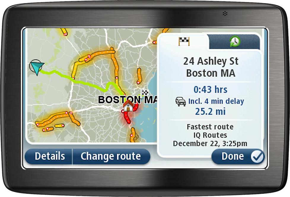
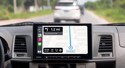
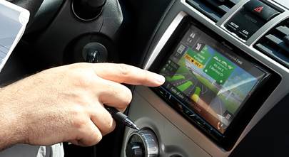
Live traffic data warns you about delays on your route
In terrestrial FM applications, the traffic signals are broadcast over the FM Radio Data System (RDS), a special application of the radio band for sending small amounts of digital information. Most car stereos support FM RDS signals, which is how you can see radio station call letters or artist and song title information on your display when tuned to certain stations.
HD Radio signals broadcast traffic data in a similar fashion, but since HD Radio signals are able to carry more information, they can provide real-time updates more rapidly — up to four times more quickly than FM RDS in some cases. Traffic reports via HD Radio signals are not limited to in-dash receivers with HD Radio tuners — they can be received through some portable GPS systems as well.
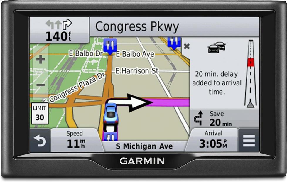
To use the service, simply program a destination into your navigation system. As you drive, your system will receive and deliver alerts whenever a traffic incident comes up. You'll get both an audible warning and a visual indicator on the navigator's map, which shows you where along your route the incident has occurred. Many systems will automatically suggest alternate routes that enable you to steer you clear of the incident ahead.
Traffic incidents include accidents, emergencies, construction, scheduled road closures, and traffic diversions for occasions such as sporting events. Some services even offer detailed information about traffic flow and the average speed along your programmed route in certain high-traffic areas of select cities.
What are the benefits?
Your primary benefit is time. More often than not, you'll get warnings of traffic incidents along your route with time enough to avoid them. And since you're using the traffic data in conjunction with a navigation system, you'll get suggestions for the most efficient alternate routes. And that means less time spent sitting in gridlock.
Traffic-information services also let you get the most out of your navigation system. Normally, you wouldn't use a GPS unit to guide you to work, or to get you back home along familiar roads. But with real-time traffic info, you'll find that your navigation system becomes an invaluable traveling tool you'll use daily.
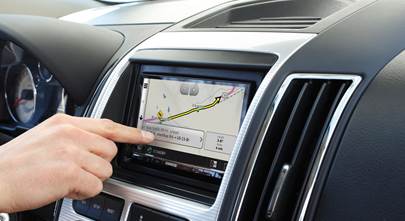
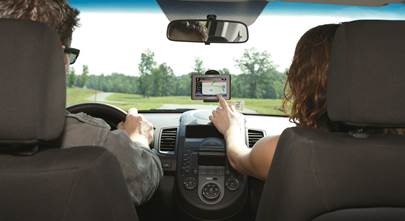
Many portable navigation devices are compatible with live traffic information services
What do I need and how much does it cost?
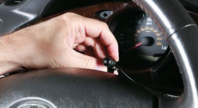
Basically, all you need to enjoy real-time traffic information is a traffic-ready navigation unit and, usually, an antenna (satellite radio antennas can pick up traffic-information signals as well, if you're using a compatible satellite radio receiver). For most portable GPS navigators, the antenna is contained within a special power cable that comes with the device or can be bought separately. But not all navigators will show traffic reports even when connected to that type of cable — they also need to have compatible built-in software and a receiver to translate those signals.
As mentioned above, some newer portable GPS units and in-dash navigation receivers include either a limited or lifetime subscription to a traffic data service, typically for free and in some cases supported by on-screen advertising. Other devices or sources require a subscription to their service. Currently, the most popular traffic-information services are provided by:
- Clear Channel's Traffic Message Channel — also known as Total Traffic & Weather Network (FM)
- HERE/NAVTEQ Traffic RDS (FM)
- SiriusXM satellite radio's NavTraffic (satellite)
Pricing depends on the source. For example, satellite radio subscription prices range from $3.99 per month (in addition to the regular satellite radio subscription) to $8.99 per month. Terrestrial FM services can cost up to $60 per year, but many manufacturers will offer a free trial of one or two years with purchase of their system.
What cities are covered?
Coverage currently includes many metropolitan areas. However, the number of cities covered has expanded quite a bit over the last few years. Check with each manufacturer to determine their areas of coverage.
App-based traffic services
As the in-dash receiver is seen more and more as an extension of the driver's phone or tablet, there has been a noticeable move toward incorporating specialized traffic apps, whether within the navigator or through a connected device. A couple of the more popular apps that are compatible with many in-dash touchscreen stereos are Waze and INRIX. Both apps rely on a combination of map-based traffic data and crowd-sourced reports from vehicles within nearby cellular networks to generate their traffic reports. These apps can be useful even in non-metropolitan areas where there isn't a dedicated traffic-info infrastructure, but they are heavily reliant on the ability to tap into cellular or even Wi-Fi® signals. If those signals are not present, the apps may be rendered next to useless. App compatibility varies depending on the stereo manufacturer, the phone, and operating system.


Bob from Winter Park
Posted on 5/4/2022
When receiving RTS/HD traffic over the air (Garmin GTM-60), what is the radius of coverage from your current metro area does the traffic information extend? If I rout from Orlando to Atlanta, will all the current traffic info all the way to Atlanta be downloaded when I am still in Orlando? Or will the traffic information for the Atlanta area not be available until I am physically in that market/local radio reception area? Thank you.
Antoinette de Janasz Baxter from Rockwall
Posted on 2/20/2019
FYI, SiriusXM NavTraffic does not provide any data for toll roads. After calls to Sirius tech support and getting nowhere, I asked about it when I took my car into the dealership for service. They told me that there's nothing wrong with my navigation system, it's SiriusXM not providing the data. It took half an hour on the phone today with two Sirius representatives before I was transferred to a supervisor. She finally admitted that was the case and refunded my subscription fees.
Cody from Albany
Posted on 9/13/2017
Something I've noticed about Clear Channel's Real Time Traffic services is that their signals are broadcast a *very* limited number of hours in my city (Albany, NY), and at a very limited range - they're useful for my afternoon commute (when I start near the city) but worthless for the morning commute (when I start north of the city). They also aren't active *between* cities (such as on the New York Thruway). As a result, for long trips, Google's virtually my only choice for traffic information; they keep traffic info 24/7 and almost everywhere there's Google Maps or Waze drivers; theirs is truly real time. It's a shame, because the Pioneer U280 Navi system is very powerful and flexible, far more so than Google Maps. It just doesn't have traffic information very much of the time.
Alexander Hrabe from Crutchfield
Posted on 8/4/2017
Michael, Fiat is correct. If you add an aftermarket SiriusXM tuner, you'll need to use an aftermarket radio in place of the factory radio. If you decide that's what you'd like to do, give us a call. We can help you with that.
Michael Katze from Seattle
Posted on 8/1/2017
Can anyone help me. Just bought a brand new 2017Fiat with a Tom Tom nav system. But it cannot accept traffic according to Sirius/xm. Fiat says I am stuck as it is factory installed. Is there any way at all to add traffic. Via an antenna or whatever. Any help will be appreciated. Michael
Alexander Hrabe from Crutchfield
Posted on 5/26/2017
Joel, if you need help with your factory navigation, that would be a question for your Toyota dealer. However, we can certainly help you with a car stereo with GPS or a portable navigator. Just give us a call.
Joel polster from Dc
Posted on 5/24/2017
Do you have any phone nos to contact Clear Channel and Here/Navteq. I have only been able to contact via email and have not received any response. I would like to see if service is available for my 2013 avalon. Thanks
Mike Spaulding
Posted on 4/7/2017
Honestly, the traffic updates on Google Maps (which is free) are pretty dead-on. Waze even more so. I think it's unnecessary to buy a subscription service for this feature these days.
Alexander Hrabe from Crutchfield
Posted on 12/21/2015
Joe, according to SiriusXM's site, a minimum 1-year subscription is required if you do not subscribe to regular SiriusXM service.
Joe Forbes from Virginia Beach
Posted on 12/20/2015
very good article. However, I believe that you can subscribe to SiriusXM NAVTraffic service without adding an additional regular satellite radio subscription; at least this is what their customer service told me. I am debating on a SiriusXM subscription since I've about so many complaints regarding their service online.