


About the Jensen NAV104

Add navigation to your Jensen receiver
Add navigation to your Jensen receiver
Jensen's NAV104 system adds GPS guidance to 2012 navigation-ready Jensen in-dash receivers. The system includes a SD card that's loaded with detailed maps of the United States, including Alaska, Hawaii, and Puerto Rico, and features over 11 million points of interest. When you need to update maps, just download the info onto the SD card and you're ready to go.
Full of features
The system provides turn-by-turn directions so you can get to your destination quickly and easily. You'll enjoy easy-to-read maps with 3D and building views, along with lane assist and voice prompts that warn you of upcoming turns. Select from 2D or 3D views for your map display.
Product highlights:
- in-car navigation system for select Jensen DVD receivers
- GPS antenna
- SD card included with maps of all 50 states and Puerto Rico (with 11 million points of interest)
- 3D landmark and building maps
- voice prompts, with selectable language and voice
- warranty: 1 year
- MFR # NAV104
What's in the box:
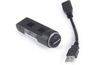
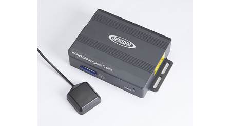
- Hide-away add-on navigation module
- 4GB SD card (with map data)
- 13' SmartBus cable (with proprietary connectors on each end)
- Magnetic base GPS antenna (with an attached 16.25' cable terminated by a SMB connector)
- One M3 x 10mm screw
- One 2M x 10mm screw
- 4 Self-adhesive rubber pads
- Operating Instructions
- Installation Guide"STOP" sheet
Customer reviews for Jensen NAV104
Loading...
Loading reviews...
Thanks for submitting your review
Customer photos


This review was collected as part of a promotion
Pros:
Cons:

More details on the Jensen NAV104

Product Research
Features
Overview: The Jensen NAV104 is an add-on GPS Navigation module for select Jensen multimedia head units. The NAV104 is driven by iGo Primo software featuring turn-by-turn audible/visual guidance with lane assist, 3D landmarks and building graphics, plus TeleAtlas US maps with over 11 million POIs (points of interest). The system also offers 19 on-screen display languages, and text-to-speech recorded voice guidance in English, French and Spanish.
Compatibility: The Jensen NAV104 is designed specifically for select 2012 Jensen navigation-ready multimedia head units. The NAV104 is compatible with the following Jensen multimedia head units (as of 5/9/2012).
- VM9215BT
- VM9225BT
- VM9216BT
- VM9226BT
Installation: The NAV104 hide-away add-on navigation module should be installed under the back or front seat. It can also be installed in the trunk, if necessary. The unit is supplied with a 13' SmartBus cable to connect to your compatible Jensen multimedia head unit. The navigation module features integrated mounting brackets to secure the unit in place (screws not supplied). You should not install the NAV104 where it will come in contact with water or direct sunlight.
TeleAtlas Map Data: The Jensen NAV104 provides map data of the United States (including Alaska and Hawaii), plus Puerto Rico from TeleAtlas. The TeleAtlas map database includes 11 million POIs (points-of-interest). The map database was created using high-resolution aerial and land based data collection. The map data is stored on the included 4GB SD card, which must be inserted into the hide-away add-on navigation module and remain installed during navigation.
Note: Car navigation maps are frequently updated. While the database was judged to be as accurate as possible at the time of its release, a map database can never be 100% accurate. Road information that is maintained in the map databases, such as turn restrictions or road names may change over time.
Map Updates: The NAV104 comes with a "Latest Map Guarantee" which must be used within 90 days of initial activation. It is easy to keep the navigation system up to date. Simply download new map data from www.naviextras.com onto the included 4GB SD memory card.
iGo Primo Software: The NAV104 uses iGo primo software which provides turn-by-turn visual and voice assistance to direct you to your selected destination. The software quickly calculates step-by-step directions to any destination available on the included navigation map. The iGo primo software's computer considers vehicle speed and heading changes, together with longitude and latitude information, to accurately determine vehicle heading and position on a digital map.
GPS (Global Position System): The iGo primo software uses Global Positioning System (GPS) satellites, and a digital roadway map database to calculate and display travel directions. The system's GPS antenna receives signals from a constellation of 24 satellites orbiting the earth and uses the strongest signals to determine your position to within meters. Signals from GPS satellites are used to determine the vehicle location. Three (good) or four (best) satellites must be received to accurately determine location. The GPS reception status is indicated by the GPS symbol on the map.
GPS Antenna: The Jensen NAV104 features an external GPS antenna. The antenna features a 16.25' cable and a magnetic base. The preferred antenna location, free from obstruction) is on the top of the vehicle (roof or trunk area). When placed on the dashboard of a vehicle, performance may be reduced due to obstruction caused by the vehicle's windshield or roof. The antenna measures 1.375" wide x 0.5" tall x 1.5625" deep.
TTS (Text-to-Speech) Voice Guidance: The Jensen NAV104 offers TTS (text-to-speech) voice guidance in English, French, or Spanish. While the navigation system is speaking, you can adjust the volume from your compatible Jensen multimedia head unit. The Navigation volume will remain at this level and when done speaking will return to the previous source at the volume level set for that source.
Note: While navigating, other sources may be selected and listened to such as AM-FM Tuner, CD, etc. Navigation voice prompts will still be heard automatically, although the navigation map cannot be seen.
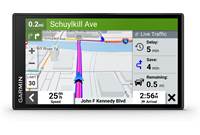
Map Screen: The NAV104 displays an on-screen map on your compatible Jensen multimedia head unit that shows your vehicle's current position (a red arrow by default), the recommended route (an orange line), the surrounding map area, and your destination as a checkered flag. The on-screen map shows streets, roads, and highways in a way that is similar to how a paper road map show them. A road's width and colors corresponds to their importance, so you can easily tell a freeway from a small street. When navigating a route, the top section of the map screen shows information about your next route maneuver and the next street or the next city/town. When approaching a turn, the map screen will zoom in and raise the view angle to let you easily recognize your maneuver at the next junction. If the next turn is at a distance, it will zoom out and lower the view angle to be flat so you can see the road in front of you. The map also displays data; such as the posted speed limit, your current speed, current time, distance to your destination, time left before you reach your destination, and your arrival time.
- 2D/3D Map Mode: The NAV104 allows you to view its on-screen map in a 2D (two-dimensional) or 3D (three-dimensional) view. Similar to paper road maps, the 2D mode, shows you streets, roads, and elevation by color. In 3D mode, you can see the altitude and elevations differences. You can distinguish between valleys, mountains, and elevated roads. In selected cities 3D landmarks and 3D buildings are also displayed.
- Color Mode: The navigation map screen uses different color themes (Day/Night) during the day and during the night for both the map and the menu screen. Daytime colors are similar to paper road maps, and the menus are bright. The nigh color themes use dark colors for large objects to keep the average brightness of the screen low. You can also set the navigation unit to switch between daytime and night color modes automatically based on the current time and GPS position.
3D Objects: The Jensen NAV104 will display 3D objects on your compatible Jensen multimedia head unit. 3D terrain map data shows changes in terrain, elevations or depressions in the land when you view the map in 2D, and use it to plot the route map in 3D when you navigate. Hills and mountains are shown in the background of the 3D map, and illustrated by color and shading on the 2D map. Complex intersections and vertically isolated roads (such as overpasses or bridges) are displayed in 3D. Landmarks are 3D artistic or block representations of prominent or well-known objects.
Lane Information & Signposts: When navigating on multilane roads, it is important to take the appropriate lane in order to follow the recommended route. If lane information is available in the map data, iGO primo displays the lanes and their directions using small arrows at the bottom of the map. Highlighted arrows represent the lanes you need to take. Where additional information is available, signposts substitute arrows. Signposts are displayed at the top of the map. The color and style of the signposts are similar to the real ones you can see above road or by the roadside. They show the available destinations and the number of the road the lane leads to. All signposts look similar when cruising (when there is no recommended route). When navigating a route, only the signpost that points to the lane(s) to be taken is displayed in vivid colors; all others are darker.
Junction View: If you are approaching a freeway exit or a complex intersection and the needed information exists, the map is replaced with a 3D view of the junction. The lanes you need to take are displayed with arrows. Signposts can also be present if information is available.
Where Am I?: This screen contains information about the current position (or approximately the last known position if GPS reception is not available) and a button to search for POIs nearby.
Destination Search: You can select your destination by entering an address or selecting a place-of-interest (POI), a location on the map, or one of your Favorite destinations. You can also look up your recent destinations from the Smart History, or enter a coordinate.
| Destination Search | Description |
|---|---|
| Find on Map | Search for a destination by scrolling the map display. |
| Home | Store and easily recall your home address. |
| Find Address | Enter full/partial address, or Search for a city (central location), or Search for the intersection of two roads. |
| Find Places | Search for over 11,000,000 points-of-interest (POIs) by name, or category; search near your current location, in a specific city, along your current route, or near your destination. |
| Favorites | Store your favorite locations for easy recall. |
| Smart History | Destinations that you have set previously |
| Coordinates | Enter geographic coordinates (latitude & longitude). |
Route Calculation: The Jensen NAV104 calculates your route based on your Vehicle Type, Route Method, and Avoidances.
- Vehicle Type: You select what type of vehicle you are driving, so the navigation unit can determine the best route based on your vehicle type (Car, Truck, Emergency, Bus, or Taxi).
- Route Method: You can choose which route method
(Fastest, Shortest, Green, Economical, or Easy) the navigation unit should
use when calculating your route.
- Fastest: give a quick route, if you can travel at or near the speed limit on all roads. Usually the best section for fast and normal cars
- Shortest: gives a route that has the smallest total distance of all possible routes. It can be practical for slow vehicles
- Green: gives a quick, but full efficient route based on the fuel consumption data you provide
- Easy: results in a route with fewer turns and no difficult maneuvers
- Avoidances: You can tell the navigation unit to avoid certain types of roads along your calculated route, such as - Highways, Tolls, Carpool/HOV, Unpaved Roads, and/or Ferries.
Way Points: You can add intermediate destinations along your main route.
Alert Point: You can save any map location as an alert point (for example a speed camera or railroad crossing).
Itinerary: While navigating, you can view a turn-by-turn list (itinerary) of upcoming maneuvers.
Trip Computer: The Trip Computer provides information about your vehicle speed, trip related timing, elevation, odometer, and clock readings.
Automatic Route Recalculation: The unit will automatically recalculate your route if you stray from the navigation unit's previously calculated route.
Route Simulation: You can preview all the route information and simulate travel along a projected route.
The Jensen NAV104 replaces these items
Jensen NAV-102
- GPS navigation system for use with compatible Jensen in-dash DVD players
- built-in road maps of the U.S. and Canada with 11 million POI
- voice guidance with selectable language and voice
Loading...
Loading accessories...
Customer Q&A
Loading...
Loading articles...