


About the Garmin GPSMAP 66i

Find your way and stay in touch
Find your way and stay in touch
Garmin's GPSMAP 66i handheld GPS navigator keeps you on the right track out of doors with its preloaded maps, electronic compass, and barometric altimeter. It also boasts topographic maps to help you find your way up and down elevated and depressed terrain. Its rugged waterproof housing keeps it safe on the trail. Speaking of safety, this handheld can communicate with the Iridium global satellite network via Garmin's inReach® wireless technology, so you can always send out a distress call if you get lost, injured, or hampered by bad weather out in the wild.

A big, bright display and plenty of battery life
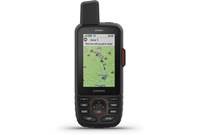
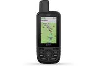
The 3" color screen on the GPSMAP 66i lets you check out the included worldwide basemap and topographic maps, even in direct sunlight. The navigator's expedition mode offers up to 200 hours of battery life while using inReach technology, while the default mode tracks your location every 10 minutes for up to 35 hours of life with the rechargeable battery.
Topo maps and basemap, plus support for more
The GPSMAP 66i comes preloaded with worldwide basemap with shaded relief, plus Garmin TopoActive mapping for North and Central America. You also get direct-to-device BirdsEye Satellite Imagery downloads, giving you a photographic aerial perspective of your surroundings. The navigator's compatible with a wide selection of add-on maps, including topographic, automotive turn-by-turn, custom, and marine maps and charts from Garmin, plus raster and vector maps. It also supports geocaching GPX files so you can download adventures straight to your device, saving paper and giving you more time to search.
Get your bearings
The GPSMAP 66i features a quad helix antenna and sensitive GPS receiver so it'll find you in a hurry and lock on to your position, whether you're in a deep canyon and under thick foliage, or surrounded by skyscrapers. The handheld's 3-axis electronic compass and barometric altimeter help keep you on course.
Maintain contact with the Garmin Explore app and inReach technology
Garmin's Explore app lets you map, sync, and share your treks from anywhere, including regions without cell coverage. And the app's your lifeline to the Iridium global satellite network, so when you trigger an SOS the GEOS 24/7 emergency response team will track your device and contact the nearest emergency responders. If you're part of an expedition, text communication with the rest of your crew is easy as long as you're all using compatible Garmin handhelds, wearables, or other mobile devices — you also get LiveTrack location sharing so people can follow your position remotely. A subscription is required to access the Iridium global satellite network.
More maps? Of course!
The GPSMAP 66i offers 16 GB of onboard memory, so you can download additional topo, marine, and road maps with ease. It'll also accept maps via microSD™ card. Garmin's Custom Maps feature lets you transform your old paper and electronic maps into downloadable maps you can transfer to the handheld, for extra backup.
Take the experience online
Garmin's Explore app is one way get more from your GPSMAP 66i, but it's not the only one. The Garmin Connect app keeps you up-to-date on weather alerts, including predictive maps for temperature, wind, precipitation, and clouds — all through your mobile device with cell service. It also connects you with Geocaching Live for real-time fun as new caches are uploaded nearby. And you can keep up with other Garmin users through the Garmin Connect online community, where you can find new places to discover and trails to explore.
Product highlights:
- handheld GPS navigator with satellite communication capability
- USB cable, carabiner, and built-in rechargeable battery with up to 35 hours of life (200 hours in expedition mode)
- 3" TFT color display (240 x 400 pixels)
- 16GB internal memory (expandable with optional microSD memory cards)
- SOS feature: alerts GEOS 24/7 emergency response
- barometric altimeter and 3-axis electronic compass
- built-in Bluetooth connectivity
- built-in ANT+ connectivity
- built-in Wi-Fi connectivity
Navigation Features:
- built-in worldwide basemap with shaded relief
- built-in TopoActive maps of North America and Central America
- compatible with optional Garmin maps:
- CityNavigator (turn-by-turn directions)
- BlueChart g2 HD marine charts
- custom, raster, and vector maps
- includes access to BirdsEye Satellite Imagery for real-life aerial terrain views
- compatible with GPS and Galileo tracking satellites
- stores up to 10,000 waypoints and 250 routes
inReach Satellite Communication Features (subscription required):
- send and receive texts
- worldwide GEOS-supported 24/7 emergency monitoring
- LiveTrack
- works with Garmin's Explore app on compatible smartphones (no cell signal necessary)
Other Features & Specs:
- compatible with Garmin Connect and Garmin Explore smartphone apps
- hunt/fish calendar and sun/moon information
- Active Weather display and/or Geocaching Live when paired with Garmin Connect smartphone app
- flashlight and picture viewer
- waterproof rating: IPX7
- dimensions: 2-5/8"W x 6-7/16"H x 1-7/16"D
- weight: 8.5 oz.
- warranty: 1 year
- MFR # 010-02088-01
What's in the box:
Garmin GPSMAP 66i owner's manual
- Handheld GPS and Satellite communicator
- Carabiner clip
- 40" USB cable (Type A USB on one end and Micro-B USB on other end)
- Quick Start Manual
- Important Safety and Product Information
- BirdsEye Direct-to-Device sheet
Customer reviews for Garmin GPSMAP 66i
Loading...
Loading reviews...
Thanks for submitting your review
Customer photos


This review was collected as part of a promotion
Pros:
Cons:

More details on the Garmin GPSMAP 66i

Product Research
Features
Overview: The Garmin GPSMAP 66i is a handheld GPS device and Satellite Communicator for use during many outdoor activities, such as boating, hunting, fishing, or hiking. It includes a 3" full color display with a resolution of 200 x 400 pixels. It is powered by a built-in Lithium-ion rechargeable battery with up to 35 hours of battery life in 10-minute tracking mode. The GPSMAP 66i has preloaded Garmin TOPO maps, with Direct-to-Device BirdsEye Satellite Imagery downloads. You can also add the optional inReach weather forecast service, if desired. The rugged GPSMAP 66i has an IPX7 waterproof rating, and weighs 8.5 ounces. It comes with a handy carabiner clip to secure it to your gear or clothing.
Global Satellite Receiver: The GPSMAP 66i includes support from multiple Global Navigation Satellite Systems (GNSS), including GPS and Galileo. You can toggle WAAS (Wide Area Augmentation System) / EGNOS (European Geostationary Navigation Overlay Service) on or off, if needed. In addition, the device has an electronic compass, barometer, and altimeter to help you as you navigate.
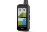
TOPO Maps/Satellite Imaging: The device is preloaded with Garmin TOPO maps for North and Central America that provide detailed views of terrain contours, topographic elevations, and summits, as well as parks, rivers, lakes, coastlines, and geographical points. You can also get BirdsEye Satellite Imagery directly downloaded to your device. This provides high resolution photo-realistic views of your route, trailheads, clearings, and more. The $29.99 subscription lasts for 1 year (from activation), and the imagery downloaded to your device during the year does not expire. You can renew after 1 year to receive further updates.
GPS Navigation and Tracking: After selecting a destination, the GPSMAP 66i can help you navigate to it. You can navigate using the map or the electronic compass. On the map, your route appears on the map as a magenta line, your location as a blue triangle. As you travel, the triangle moves and displays your path. Using the compass, an arrow points toward your destination, regardless of the direction you are moving. As you travel, the device records your path as an activity. The recording contains information about points along your path, including time, location, and elevation. Once you have reached your destination, you can navigate back to the beginning of your activity using TracBack.
inReach: The GPSMAP 66i has inReach technology to give you access to the Iridium satellite network for tracking and messaging, including sending an SOS. You can send and receive custom and preset text messages or emails, and receive a confirmation of its delivery. In case of an emergency, you can trigger an interactive SOS to the GEOS 24/7 search and rescue monitoring center. Pressing the dedicated SOS button sends a message to the International Emergency Rescue Coordination Center (IERCC), and they will notify the appropriate emergency responders of your situation. Of course, you should only use the SOS function in a real emergency.
inReach Weather: The optional inReach Weather Service provides detailed updates of the weather on your GPSMAP 66i device. You can request weather forecasts for your current location, or other waypoints or destinations where you'll be traveling. Cellular connectivity (through your mobile device and Garmin Connect app) is required for Active Weather, which includes up-to-date forecasts, and maps of predicted temperature, wind, precipitation, and cloud cover.
Mobile Connectivity: The GPSMAP 66i can connect via Bluetooth to your mobile device to provide additional connected features. Your smartphone will need the Garmin Connect app to pair to the device. Connected features include:
- Bluetooth Sensors: connect to heart rate monitors or other sensors
- EPO Downloads: Extended Prediction Orbit files help you quickly locate GPS satellites, reducing the time to obtain a GPS fix.
- Garmin Explore: share waypoints, tracks, and routes with your device by syncing with the Garmin Explore app. You can download maps to your smartphone to access when offline.
- Live Geocache Data: gives you paid or subscription-free services to view live geocache data
- LiveTrack: allow friends and family to follow your activities in real time
- Phone Notifications: Displays phone notifications on your GPSMAP 66i device
- Software Updates: The app lets you load software updates directly to your device.
Geocaching: Geocaching is a treasure hunting activity in which players hide or search for hidden caches using clues and GPS coordinates. You can register the GPSMAP 66i with geocaching.com to search for a list of nearby geocaches. Using your device, you can search for and download a geocache, view the details, navigate to the geocache, and log your results.
Battery: The GPSMAP 66i has a built-in Lithium-ion rechargeable battery. The battery charges via USB, using the included Micro USB cable and a USB charging port (on your computer or via a USB wall charger). The USB port is protected by a weatherproof cap. There are various ways to maximize battery life in the settings menu. Battery life is dependent upon your device settings:
| Mode | Typical Battery Life |
|---|---|
| Expedition/Power Save Mode (30-min Live Track Interval) | Up to 200 hours |
| Default Mode (10-min Live Track Interval) | Up to 35 hours |
| Unit Turned Off | Up to 1 year |
Loading...
Loading accessories...
Customer Q&A
3 questions already asked
Loading...
Loading articles...